IMAGES TAKEN NEAR TO
Clos Delyth, SWANSEA, SA4 4PL
Introduction
This page details the photographs taken nearby to Clos Delyth, SA4 4PL by members of the Geograph project.
The Geograph project started in 2005 with the aim of publishing, organising and preserving representative images for every square kilometre of Great Britain, Ireland and the Isle of Man.

There are currently over 7.5m images from over14,400 individuals and you can help contribute to the project by visiting https://www.geograph.org.uk
Image Map
Images are licensed for reuse under creativecommons.org/licenses/by-sa/2.0
Notes
- Clicking on the map will re-center to the selected point.
- The higher the marker number, the further away the image location is from the centre of the postcode.
Image Listing (15 Images Found)
Images are licensed for reuse under creativecommons.org/licenses/by-sa/2.0
Image
Details
Distance
1
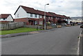
Ffordd Eira houses, Gorseinon
Viewed from the corner of Heol Eifion.
Image: © Jaggery
Taken: 29 Sep 2013
0.02 miles
2
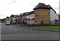
Heol Eifion houses, Gorseinon
Viewed from the corner of Ffordd Eira.
Image: © Jaggery
Taken: 29 Sep 2013
0.05 miles
3
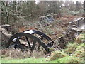
Melin Mynach, Gorseinon
Sefydlwyd melin yd ar y safle hon yn 1150 gan fynachod Sisteriaid Abaty Nedd. Er mwyn gweithio'r rhod bu raid adeiladu ffos filltir o hyd o Afon Lliw. O 1722 hyd at 1819 addaswyd Melin Mynach i fod yn felin bapur. Ar ol bod yn segur am rai blynyddoedd fe'i prynwyd yn 1852 gan William Lewis ac yn yn 1874 fe adeiladodd yn 1874 ffatri wlan newydd ar y safle. Daeth y fenter hon i ben yn 1913 ac yn araf deg fe ddirywiodd yr adeiladau. Wedyn amgylchynwyd y felin gan waith alcam a phwll glo ac fe ddaeth y safle yn dip sbwriel. Daeth adefeilion i'r golwg unwaith eto pan gloddiwyd y safle yn ystod y 1990au gan archaeolegwyr. Yn anffodus, mae'r safle bellach wedi cael ei hesgeuluso ac yn llawn o ganiau cwrw.
A grist mill was established on this site by the Cisterscian monks of Neath Abbey in 1150. To power the water wheel a leat measuring a mile in length had to be constructed from the Lliw River. In 1722 the mill known as Melin Mynach (trans. Monks Mill) was adapted as a paper mill which continued up until 1819. After remaining idle for several years the mill was bought in 1852 by William Lewis who later built in 1874 a substantial woollen mill on the site. This ceased production in 1913. The buildings soon began to fall into disrepair particularly when the site was surrounded by a tinplate works and a coal mine. The mill then disappeared after it became an industrial waste dump. During the 1990's an archaeological dig uncovered what remains today. Sadly, the site has been allowed to become neglected and is littered with beer cans.
Image: © Alan Richards
Taken: 26 Jan 2012
0.08 miles
4
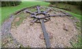
Wheel display in Parc Melin Mynach
This display is right next to the park entrance on the corner of Cecil Road and is made from parts of an 18th century cast iron water wheel retrieved from this site.
The park is a former industrial area that was left to become wasteland and later reclaimed. Unexpectedly, part of an old mill was found and excavated. See Image
The wheel in Alan's photo is a modern substitute.
Unfortunately, less and less of the old wheel remains as time goes by, due to metal thieves or vandals. The redundant brick supports hint at spokes that have gone missing since the display was originally created.
Image: © Nigel Davies
Taken: 5 Oct 2013
0.12 miles
5
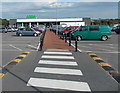
Path through the car park to Asda in Gorseinon
Pedestrians access the store from Cecil Road.
Image: © Jaggery
Taken: 29 Sep 2013
0.13 miles
6
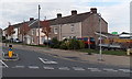
Mill Street houses, Gorseinon
Viewed across Cecil Road from High Street.
Image: © Jaggery
Taken: 29 Sep 2013
0.19 miles
7
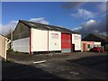
O'Brien's Metals
Scrap metal merchants in Gorseinon.
Image: © Alan Hughes
Taken: 5 Nov 2017
0.20 miles
8
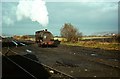
Steam at Gorseinon ? 1969
National Coal Board shunting locomotive, seen working the sidings serving Mountain Colliery on the site of the original London and North Western Railway's Gorseinon Station which closed in 1964. The locomotive was built by the Bristol firm of Peckett and Sons in 1916, works number 1410, originally attached to nearby Brynlliw Colliery which had closed some years previously. For a more recent view of the location, see https://www.geograph.org.uk/photo/3886017
Image: © Alan Murray-Rust
Taken: 24 Nov 1969
0.21 miles
9
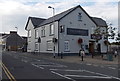
The Mardy Inn, Gorseinon
The Mardy at 117 High Street Gorseinon dates from about 1900. It had a chequered history in the early years of the 21st century, and closed towards the end of 2011.
After a major revamp, it reopened as a J D Wetherspoon pub on April 30th 2013.
Image: © Jaggery
Taken: 29 Sep 2013
0.23 miles
10
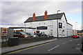
The Mardy Inn, Gorseinon
Now a Wetherspoon's following a refurbishment of a traditional pub in 2013.
Image: © Bill Boaden
Taken: 6 Apr 2016
0.23 miles