IMAGES TAKEN NEAR TO
Alexandra Road, SWANSEA, SA4 4NU
Introduction
This page details the photographs taken nearby to Alexandra Road, SA4 4NU by members of the Geograph project.
The Geograph project started in 2005 with the aim of publishing, organising and preserving representative images for every square kilometre of Great Britain, Ireland and the Isle of Man.

There are currently over 7.5m images from over14,400 individuals and you can help contribute to the project by visiting https://www.geograph.org.uk
Image Map (Loading...)


Getting Data...Please wait
Leaflet Map data © OpenStreetMap
Images are licensed for reuse under creativecommons.org/licenses/by-sa/2.0
Notes
- Clicking on the map will re-center to the selected point.
- The higher the marker number, the further away the image location is from the centre of the postcode.
Image Listing (107 Images Found)
Images are licensed for reuse under creativecommons.org/licenses/by-sa/2.0
Image
Details
Distance
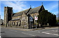
1
St Catherine's Church, Gorseinon (Recreated)
This is a recreation of the old photo from the Frith collection here: http://www.francisfrith.com/search/wales/west+glamorgan/gorseinon/photos/gorseinon_87815.htm
The original photo was taken from closer to the ground but someone's front garden wall now blocks that view.
Image: © Nigel Davies
Taken: 28 Dec 2006
0.03 miles
2
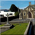
Gorseinon and District War Memorial
Located in the SW corner of the churchyard of St Catherines Church, the stone Celtic Cross was dedicated as a Great War Memorial in 1922. The church hall is in the background.
Image: © Jaggery
Taken: 29 Sep 2013
0.03 miles
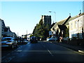
4
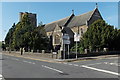
Alexandra Road houses between two churches, Gorseinon
Viewed from the edge of the Church of the Blessed Sacrament http://www.geograph.org.uk/photo/5000943
looking towards St Catherine's Church tower http://www.geograph.org.uk/photo/3682059
Image: © Jaggery
Taken: 25 Mar 2016
0.03 miles
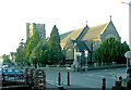
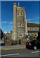
5
St Catherine's Church Gorseinon
Located on the corner of Alexandra Road and Princess Street, the church was consecrated and dedicated in May 1913. It is part of the Church in Wales Diocese of Swansea and Brecon. The building was Grade II listed in 2002.
Image: © Jaggery
Taken: 29 Sep 2013
0.03 miles
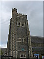
6
St Catherine's Church tower Gorseinon
Viewed across Alexandra Road.
The tower is in the SW corner of the Church in Wales church. http://www.geograph.org.uk/photo/3681992
Image: © Jaggery
Taken: 29 Sep 2013
0.03 miles
7
Gorseinon Church
The Ordnance Survey used the tower flagstaff as a 3rd Order Triangulation Point (Intersected Station SN61/INT002).
Image: © Adrian Dust
Taken: 11 Apr 2011
0.03 miles
8
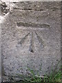
Ordnance Survey Cut Mark
This OS cut mark can be found on St Catherine's Church. It marks a point 30.654m above mean sea level. http://www.geograph.org.uk/photo/3754773
Image: © Adrian Dust
Taken: 9 Jun 2014
0.03 miles
9
St Catherine's Church Gorseinon
Part of the Church in Wales Diocese of Swansea and Brecon, St Catherine's Church is on the corner of Alexandra Road and Princess Street. The church was consecrated and dedicated in May 1913, Grade II listed in 2002.
Image: © Jaggery
Taken: 25 Mar 2016
0.03 miles
10
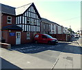
Penybryn Surgery Gorseinon
Located in Alexandra Road near the corner of Penybryn Road.
Image: © Jaggery
Taken: 29 Sep 2013
0.03 miles