IMAGES TAKEN NEAR TO
Swansea Road, SWANSEA, SA4 4LL
Introduction
This page details the photographs taken nearby to Swansea Road, SA4 4LL by members of the Geograph project.
The Geograph project started in 2005 with the aim of publishing, organising and preserving representative images for every square kilometre of Great Britain, Ireland and the Isle of Man.

There are currently over 7.5m images from over14,400 individuals and you can help contribute to the project by visiting https://www.geograph.org.uk
Image Map (Loading...)


Getting Data...Please wait
Leaflet Map data © OpenStreetMap
Images are licensed for reuse under creativecommons.org/licenses/by-sa/2.0
Notes
- Clicking on the map will re-center to the selected point.
- The higher the marker number, the further away the image location is from the centre of the postcode.
Image Listing (2 Images Found)
Images are licensed for reuse under creativecommons.org/licenses/by-sa/2.0
Image
Details
Distance
1
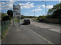
Pentre'r Ardd. Garden Village.
Edrych tua Abertawe.
Looking towards Swansea.
Image: © Gerallt Pennant
Taken: 18 Apr 2007
0.13 miles
2
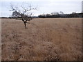
Mynydd Carn Goch Roman Practice Camp
Lle mae'r golfen gellir gweld cornel gwersyll ymarfer Rhufeinig ar Fynydd Carn Goch. Mae'r gwersyll yn mesur 87 troedfedd sgwar ac ar bob ochr ohono ceir olion o 'clavicula' sef mynediad amddiffynnol. Mae'r gwersyll yn un o ddau a godwyd ar y comin. Adeiladwyd y gwersylloedd ar ol i'r Rhufeiniaid feddiannu'r ardal oddeutu 75 OC a sefydlu caer barhaeol ryw dair milltir i ffwrdd ar lan Afon Llwchwr a'i alw'n Leucarum.
The tree marks one corner of a Roman practice camp located on Mynydd Carn Goch. The practice camp is one of a pair and it measures 87 ft square and on each side it has a defensive entrance called a 'clavicula'. The camps were built sometime after the Romans occupied the area in c75 AD and where a permanent fort named Leucarum was established approximately three miles away on the banks of the Llwchwr River (Loughor).
Image: © Alan Richards
Taken: 26 Jan 2012
0.20 miles