IMAGES TAKEN NEAR TO
Railway Terrace, SWANSEA, SA4 4EN
Introduction
This page details the photographs taken nearby to Railway Terrace, SA4 4EN by members of the Geograph project.
The Geograph project started in 2005 with the aim of publishing, organising and preserving representative images for every square kilometre of Great Britain, Ireland and the Isle of Man.

There are currently over 7.5m images from over14,400 individuals and you can help contribute to the project by visiting https://www.geograph.org.uk
Image Map
Images are licensed for reuse under creativecommons.org/licenses/by-sa/2.0
Notes
- Clicking on the map will re-center to the selected point.
- The higher the marker number, the further away the image location is from the centre of the postcode.
Image Listing (17 Images Found)
Images are licensed for reuse under creativecommons.org/licenses/by-sa/2.0
Image
Details
Distance
1
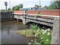
Afon Lliw Bridge
There is an Ordnance Survey Cut Mark on the south parapet.
Image: © Adrian Dust
Taken: 9 Jun 2014
0.04 miles
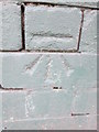
3
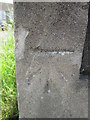
Ordnance Survey Cut Mark
This OS cut mark can be found on the south parapet of the Afon Lliw Bridge. It marks a point 12.055m above mean sea level.
Image: © Adrian Dust
Taken: 9 Jun 2014
0.05 miles
4
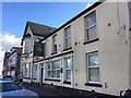
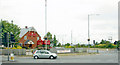
Station Hotel
The Station Hotel at Gorseinon.
Image: © Alan Hughes
Taken: 5 Nov 2017
0.09 miles
5
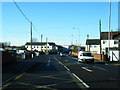
Site of Gorseinon Station
View NW On A4240 High Street at Cockle Shell Inn, to station site opposite, towards Pontardulais, Llandilo etc.: ex-LNWR Central Wales line, Pontardulais - Swansea Victoria section, closed 15/6/64; since then 'Heart of Wales' trains have run from Llandilo to Swansea via Llanelli.
Image: © Ben Brooksbank
Taken: 22 Jun 2004
0.10 miles
6
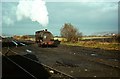
Steam at Gorseinon ? 1969
National Coal Board shunting locomotive, seen working the sidings serving Mountain Colliery on the site of the original London and North Western Railway's Gorseinon Station which closed in 1964. The locomotive was built by the Bristol firm of Peckett and Sons in 1916, works number 1410, originally attached to nearby Brynlliw Colliery which had closed some years previously. For a more recent view of the location, see https://www.geograph.org.uk/photo/3886017
Image: © Alan Murray-Rust
Taken: 24 Nov 1969
0.12 miles
7
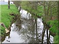
Afon Lliw at Gorseinon
Afon Lliw as it runs through Gorseinon before emptying into the Loughor Estuary.
Image: © Dave Farmer
Taken: 27 Apr 2006
0.14 miles
8
Blood, Sweat & Tears - artwork at the Gorseinon Centre
This artwork is outside the entrance of the Gorseinon Centre.
Image
It is by Ben Clegg and celebrates the role of steel making in the community - since the Centre is built near the site of the former Bryngwyn Steel Works which closed in 2001.
Image: © Nigel Davies
Taken: 30 Nov 2013
0.16 miles
9

The Gorseinon Centre
The Gorseinon Centre contains a conference centre, office space, a cafe and a nursery. It is a joint venture between the Gorseinon Development Trust, the town council, county council and the European Regional Development Fund.
Web site: http://www.gdt.org.uk/canolfannew.html
Image: © Nigel Davies
Taken: 30 Nov 2013
0.18 miles
10
Ordnance Survey Cut Mark
This OS cut mark can be found on the Dental Surgery, No40 High Street. It marks a point 15.88m above mean sea level.
Image: © Adrian Dust
Taken: 9 Jun 2014
0.20 miles