IMAGES TAKEN NEAR TO
Clos Vernon Watkins, SWANSEA, SA4 4DH
Introduction
This page details the photographs taken nearby to Clos Vernon Watkins, SA4 4DH by members of the Geograph project.
The Geograph project started in 2005 with the aim of publishing, organising and preserving representative images for every square kilometre of Great Britain, Ireland and the Isle of Man.

There are currently over 7.5m images from over14,400 individuals and you can help contribute to the project by visiting https://www.geograph.org.uk
Image Map
Images are licensed for reuse under creativecommons.org/licenses/by-sa/2.0
Notes
- Clicking on the map will re-center to the selected point.
- The higher the marker number, the further away the image location is from the centre of the postcode.
Image Listing (17 Images Found)
Images are licensed for reuse under creativecommons.org/licenses/by-sa/2.0
Image
Details
Distance
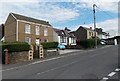
1
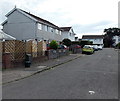
Clos Vernon Watkins, Gorseinon
Houses in the cul-de-sac Clos Vernon Watkins, viewed from the Pencefnarda Road end.
Image: © Jaggery
Taken: 29 Sep 2013
0.03 miles
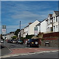
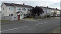
2
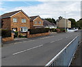
Pencefnarda Road houses, Penyrheol, Gorseinon
The houses are on the north side of Pencefnarda Road, between Penybanc Lane and Clos Vernon Watkins.
Image: © Jaggery
Taken: 29 Sep 2013
0.05 miles
3
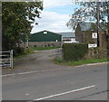
Pencefnarda Farm, Penyrheol, Gorseinon
Viewed across Pencefnarda Road.
Image: © Jaggery
Taken: 29 Sep 2013
0.05 miles
4
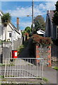
Public footpath from Penyrheol Road to Penybanc Lane, Gorseinon
The red dog waste box is a recent addition to the post
on top of which is a public footpath sign pointing ahead.
The exotic tree grows well in the usually mild climate in the Swansea area,
where killing frosts are rare.
Image: © Jaggery
Taken: 29 Sep 2013
0.07 miles
5
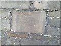
Ordnance Survey Cut Mark
This OS cut mark can be found on the wall NE side of Penyrheol Road. It marks a point 55.916m above mean sea level.
Image: © Adrian Dust
Taken: 15 Jul 2021
0.10 miles
6
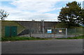
Entrance gates to a covered water reservoir in Penyrheol Gorseinon
Viewed across Pencefnarda Road.
Image: © Jaggery
Taken: 29 Sep 2013
0.10 miles
7
Side view of a covered water reservoir in Penyrheol Gorseinon
Viewed across Pencefnarda Road.
Image: © Jaggery
Taken: 29 Sep 2013
0.10 miles
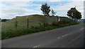
8
Southern end of Penyrheol Road Gorseinon
Penyrheol Road heads NNW away from the junction with Frampton Road and Pencaecrwn Road.
Image: © Jaggery
Taken: 29 Sep 2013
0.11 miles
9
Pencefnarda Road, Penyrheol, Gorseinon
Looking east from the corner of Llannant Road and Gowerview Road,
at the edge of Penyrheol Community Church. http://www.geograph.org.uk/photo/3682641
Image: © Jaggery
Taken: 29 Sep 2013
0.12 miles
10
Heol Elfed houses, Penyrheol Gorseinon
Viewed from the corner of Pencefnarda Road.
Image: © Jaggery
Taken: 29 Sep 2013
0.12 miles