IMAGES TAKEN NEAR TO
High Street, SWANSEA, SA4 4BT
Introduction
This page details the photographs taken nearby to High Street, SA4 4BT by members of the Geograph project.
The Geograph project started in 2005 with the aim of publishing, organising and preserving representative images for every square kilometre of Great Britain, Ireland and the Isle of Man.

There are currently over 7.5m images from over14,400 individuals and you can help contribute to the project by visiting https://www.geograph.org.uk
Image Map (Loading...)


Getting Data...Please wait
Leaflet Map data © OpenStreetMap
Images are licensed for reuse under creativecommons.org/licenses/by-sa/2.0
Notes
- Clicking on the map will re-center to the selected point.
- The higher the marker number, the further away the image location is from the centre of the postcode.
Image Listing (75 Images Found)
Images are licensed for reuse under creativecommons.org/licenses/by-sa/2.0
Image
Details
Distance
1
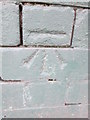
Ordnance Survey Cut Mark
This OS cut mark can be found on the Dental Surgery, No40 High Street. It marks a point 15.88m above mean sea level.
Image: © Adrian Dust
Taken: 9 Jun 2014
0.01 miles
2
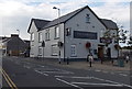
The Mardy Inn, Gorseinon
The Mardy at 117 High Street Gorseinon dates from about 1900. It had a chequered history in the early years of the 21st century, and closed towards the end of 2011.
After a major revamp, it reopened as a J D Wetherspoon pub on April 30th 2013.
Image: © Jaggery
Taken: 29 Sep 2013
0.01 miles
3
The Mardy Inn, Gorseinon
Now a Wetherspoon's following a refurbishment of a traditional pub in 2013.
Image: © Bill Boaden
Taken: 6 Apr 2016
0.02 miles
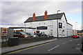
4
Lloyds Bank Gorseinon
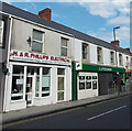
In September 2013, the Lloyds TSB name disappeared from banks. It was replaced by two separate banks. Most became Lloyds Bank, as here in High Street Gorseinon. About 630 branches (including all the Cheltenham and Gloucester branches) became TSB branches.
H&R Phillips Electrical shop is on the left.
Image: © Jaggery
Taken: 29 Sep 2013
0.03 miles
5
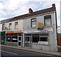
Mai Hong Chinese takeaway in Gorseinon
The High Street takeaway is next door to Karrykleen dry cleaners.
Image: © Jaggery
Taken: 29 Sep 2013
0.03 miles
6
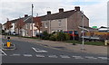
Mill Street houses, Gorseinon
Viewed across Cecil Road from High Street.
Image: © Jaggery
Taken: 29 Sep 2013
0.05 miles
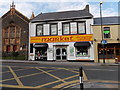
7
Shepherd's Gower sown Gower grown produce, Gorseinon
The High Street shop sells fruit and vegetables from the nearby Gower peninsula.
Image: © Jaggery
Taken: 29 Sep 2013
0.05 miles
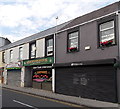
8
Gorseinon Market Shopping Centre
Located at 105-106 High Street, facing Cross Street. Seion chapel http://www.geograph.org.uk/photo/3676820 is on the left.
Image: © Jaggery
Taken: 29 Sep 2013
0.07 miles
9
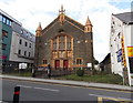
Seion Noddfa Baptist Chapel, Gorseinon
Viewed across High Street. The white inscription in Welsh above the doors shows that the chapel was built in 1902. The notice on the left is in Welsh. The one on the right shows that there is an English-language service here every Sunday morning at 10.30.
Image: © Jaggery
Taken: 29 Sep 2013
0.07 miles
10
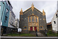
Seion-Noddfa Baptist Chapel
A Baptist chapel dating from 1902.
Image: © Bill Boaden
Taken: 6 Apr 2016
0.08 miles