IMAGES TAKEN NEAR TO
Llangrannog, LLANDYSUL, SA44 6RR
Introduction
This page details the photographs taken nearby to SA44 6RR by members of the Geograph project.
The Geograph project started in 2005 with the aim of publishing, organising and preserving representative images for every square kilometre of Great Britain, Ireland and the Isle of Man.

There are currently over 7.5m images from over14,400 individuals and you can help contribute to the project by visiting https://www.geograph.org.uk
Image Map (Loading...)


Getting Data...Please wait
Leaflet Map data © OpenStreetMap
Images are licensed for reuse under creativecommons.org/licenses/by-sa/2.0
Notes
- Clicking on the map will re-center to the selected point.
- The higher the marker number, the further away the image location is from the centre of the postcode.
Image Listing (2 Images Found)
Images are licensed for reuse under creativecommons.org/licenses/by-sa/2.0
Image
Details
Distance
1
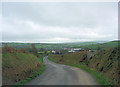
Lane to the east of Cnwcyrhyglyn
In the mid distance is Penmorfa, on the edge of the Hoffnant Valley.
Image: © Stuart Logan
Taken: 8 Oct 2011
0.13 miles
2
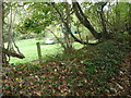
Run aground boat in Ceredigion
A boat in a field. I've seen too many for it to be a novelty. But always a curiosity. It's always amusing to construct the backstory of how it got there. This one is nearer the sea than many I have spotted. Why put it on a field edge to be overgrown rather than sell it on, or give it away, though??
Image: © Jeremy Bolwell
Taken: 23 Oct 2011
0.24 miles