IMAGES TAKEN NEAR TO
Sarnau, LLANDYSUL, SA44 6QU
Introduction
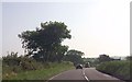
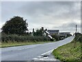
This page details the photographs taken nearby to SA44 6QU by members of the Geograph project.
The Geograph project started in 2005 with the aim of publishing, organising and preserving representative images for every square kilometre of Great Britain, Ireland and the Isle of Man.

There are currently over 7.5m images from over14,400 individuals and you can help contribute to the project by visiting https://www.geograph.org.uk
Image Map
Images are licensed for reuse under creativecommons.org/licenses/by-sa/2.0
Notes
- Clicking on the map will re-center to the selected point.
- The higher the marker number, the further away the image location is from the centre of the postcode.
Image Listing (3 Images Found)
Images are licensed for reuse under creativecommons.org/licenses/by-sa/2.0
Image
Details
Distance
1
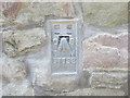
Ordnance Survey Flush Bracket S7792
This can be found on the wall of a farm building at Temple Bar.
For more detail see : http://www.bench-marks.org.uk/bm15265
Image: © Peter Wood
Taken: 21 Apr 2015
0.01 miles