IMAGES TAKEN NEAR TO
Cae Llwyni, LLANDYSUL, SA44 6QQ
Introduction
This page details the photographs taken nearby to Cae Llwyni, SA44 6QQ by members of the Geograph project.
The Geograph project started in 2005 with the aim of publishing, organising and preserving representative images for every square kilometre of Great Britain, Ireland and the Isle of Man.

There are currently over 7.5m images from over14,400 individuals and you can help contribute to the project by visiting https://www.geograph.org.uk
Image Map
Images are licensed for reuse under creativecommons.org/licenses/by-sa/2.0
Notes
- Clicking on the map will re-center to the selected point.
- The higher the marker number, the further away the image location is from the centre of the postcode.
Image Listing (11 Images Found)
Images are licensed for reuse under creativecommons.org/licenses/by-sa/2.0
Image
Details
Distance
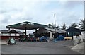
3
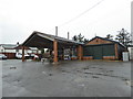
Army Surplus store at Sarnau
Always interesting to brows and shop at. Its amazing what is in these places.
Image: © Jeremy Bolwell
Taken: 3 Mar 2019
0.06 miles
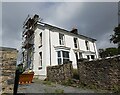
5
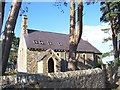
Church at Sarnau
Former Parish Church at Sarnau, now in private ownership.
Image: © Cered
Taken: 6 Sep 2005
0.20 miles
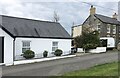
6
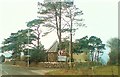
A former church at Sarnau. Now privately owned
On the crossroads between Penbryn and Rhydlewis.
Image: © Deborah Tilley
Taken: 14 Feb 2010
0.22 miles
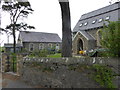
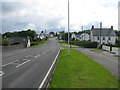
9
Passing old Sarnau church and approaching crossroads
Image: © John Firth
Taken: 11 Jul 2013
0.24 miles