IMAGES TAKEN NEAR TO
Cross Inn, LLANDYSUL, SA44 6NN
Introduction
This page details the photographs taken nearby to SA44 6NN by members of the Geograph project.
The Geograph project started in 2005 with the aim of publishing, organising and preserving representative images for every square kilometre of Great Britain, Ireland and the Isle of Man.

There are currently over 7.5m images from over14,400 individuals and you can help contribute to the project by visiting https://www.geograph.org.uk
Image Map (Loading...)


Getting Data...Please wait
Leaflet Map data © OpenStreetMap
Images are licensed for reuse under creativecommons.org/licenses/by-sa/2.0
Notes
- Clicking on the map will re-center to the selected point.
- The higher the marker number, the further away the image location is from the centre of the postcode.
Image Listing (6 Images Found)
Images are licensed for reuse under creativecommons.org/licenses/by-sa/2.0
Image
Details
Distance
3
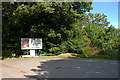
Honey Farm at Penlon
Honey Farm was closed today, too early in the year, more flowers need to be about for the bees. I have seen the odd bumble bee about!
Image: © chris whitehouse
Taken: 10 Mar 2012
0.06 miles
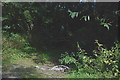
4
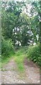
Gated Woodland Pathway Above Afon Gido
Image: © Anthony Parkes
Taken: 8 Jul 2021
0.22 miles
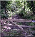
5
Start of footpath above the Afon Gido
The gate is noticeably more dilapidated than when Image was taken.
Image: © Nigel Brown
Taken: 9 Sep 2010
0.23 miles
6
Woodland path above Afon Gido
Near New Quay Honey Farm
Image: © John Duckfield
Taken: 25 Aug 2009
0.24 miles