IMAGES TAKEN NEAR TO
Synod Inn, LLANDYSUL, SA44 6JN
Introduction
This page details the photographs taken nearby to SA44 6JN by members of the Geograph project.
The Geograph project started in 2005 with the aim of publishing, organising and preserving representative images for every square kilometre of Great Britain, Ireland and the Isle of Man.

There are currently over 7.5m images from over14,400 individuals and you can help contribute to the project by visiting https://www.geograph.org.uk
Image Map (Loading...)


Getting Data...Please wait
Leaflet Map data © OpenStreetMap
Images are licensed for reuse under creativecommons.org/licenses/by-sa/2.0
Notes
- Clicking on the map will re-center to the selected point.
- The higher the marker number, the further away the image location is from the centre of the postcode.
Image Listing (2 Images Found)
Images are licensed for reuse under creativecommons.org/licenses/by-sa/2.0
Image
Details
Distance
1
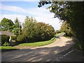
The A487 at Pontffynnonddewi, Llandissiliogogo
This is at the junction with the lane running south. I parked and was attracted by the curves in the road. Unfortunately I was standing just over the grid line!
Image: © Humphrey Bolton
Taken: 30 Sep 2007
0.20 miles
2
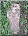
Old Milestone by the A487, Gellie, Ceredigion
Carved stone post by A487, in the community of Llandysiliogogo, Ceredigion; Gellie, back of deep verge, on South side of road. Erected by the Cardiganshire South of Aeron Turnpike Trust, C19th.
Inscription reads:-
TO
CARDIGAN
14 MILES
{arrow}
Grade II listed by CADW.
Reference Number: 16629 https://cadwpublic-api.azurewebsites.net/reports/listedbuilding/FullReport?lang=&id=16629
Milestone Society National ID: CRD_CAAY14.
Image: © Milestone Society
Taken: 25 Apr 2017
0.23 miles