IMAGES TAKEN NEAR TO
Synod Inn, LLANDYSUL, SA44 6JH
Introduction
This page details the photographs taken nearby to SA44 6JH by members of the Geograph project.
The Geograph project started in 2005 with the aim of publishing, organising and preserving representative images for every square kilometre of Great Britain, Ireland and the Isle of Man.

There are currently over 7.5m images from over14,400 individuals and you can help contribute to the project by visiting https://www.geograph.org.uk
Image Map (Loading...)


Getting Data...Please wait
Leaflet Map data © OpenStreetMap
Images are licensed for reuse under creativecommons.org/licenses/by-sa/2.0
Notes
- Clicking on the map will re-center to the selected point.
- The higher the marker number, the further away the image location is from the centre of the postcode.
Image Listing (6 Images Found)
Images are licensed for reuse under creativecommons.org/licenses/by-sa/2.0
Image
Details
Distance
1
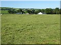
View to Caerwenlli
View across a field of cut grass to Caerwenlli.
Image: © Philip Halling
Taken: 16 Jul 2021
0.06 miles
2
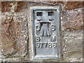
Ordnance Survey Flush Bracket S7786
This can be found on the now closed and derelict school.
For more detail see : http://www.bench-marks.org.uk/bm15277
Image: © Peter Wood
Taken: 22 May 2013
0.21 miles
3
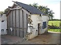
Alterations at the forge, Llandissiliogogo
Some drastic rebuilding. I hope all goes well!
Image: © Humphrey Bolton
Taken: 30 Sep 2007
0.22 miles
4

St. Mark Church
St. Mark Anglican Church, Gwenlli.
Image: © Cered
Taken: 19 Aug 2005
0.23 miles
5
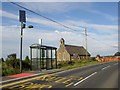
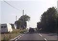
Church and bus stop, Llandissiliogogo
St Mark's Church might now be disused, as the graveyard has been dug up. The bus stop is lit by one of the new breed of solar powered street lights. Presumably there is a rechargeable battery in the box below the panel.
Image: © Humphrey Bolton
Taken: 30 Sep 2007
0.23 miles