IMAGES TAKEN NEAR TO
Plwmp, LLANDYSUL, SA44 6EP
Introduction
This page details the photographs taken nearby to SA44 6EP by members of the Geograph project.
The Geograph project started in 2005 with the aim of publishing, organising and preserving representative images for every square kilometre of Great Britain, Ireland and the Isle of Man.

There are currently over 7.5m images from over14,400 individuals and you can help contribute to the project by visiting https://www.geograph.org.uk
Image Map (Loading...)


Getting Data...Please wait
Leaflet Map data © OpenStreetMap
Images are licensed for reuse under creativecommons.org/licenses/by-sa/2.0
Notes
- Clicking on the map will re-center to the selected point.
- The higher the marker number, the further away the image location is from the centre of the postcode.
Image Listing (6 Images Found)
Images are licensed for reuse under creativecommons.org/licenses/by-sa/2.0
Image
Details
Distance
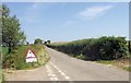
1
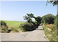
Minor road to Ffynnon-iwan
From road junction east of Plwmp
Image: © John Firth
Taken: 9 Jul 2013
0.05 miles
2
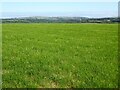
Farmland east of Plwmp
View to the north over farmland to the east of Plwmp. Low cloud is lying above the sea in the distance.
Image: © Philip Halling
Taken: 16 Jul 2021
0.11 miles
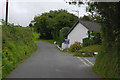
3
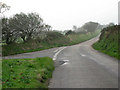
Junction in the mist
On perhaps a typical West Welsh October morning, this T-junction east of Plwmp offers a return to the main coast road through Cardiganshire.
Image: © Zorba the Geek
Taken: 3 Oct 2007
0.11 miles
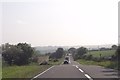
6
Road junction near Ddol farm
The route ahead leads directly to the A487, that on the right goes via Plwmp.
Image: © Nigel Brown
Taken: 3 Aug 2010
0.25 miles