IMAGES TAKEN NEAR TO
Blaencelyn, LLANDYSUL, SA44 6DH
Introduction
This page details the photographs taken nearby to SA44 6DH by members of the Geograph project.
The Geograph project started in 2005 with the aim of publishing, organising and preserving representative images for every square kilometre of Great Britain, Ireland and the Isle of Man.

There are currently over 7.5m images from over14,400 individuals and you can help contribute to the project by visiting https://www.geograph.org.uk
Image Map
Images are licensed for reuse under creativecommons.org/licenses/by-sa/2.0
Notes
- Clicking on the map will re-center to the selected point.
- The higher the marker number, the further away the image location is from the centre of the postcode.
Image Listing (7 Images Found)
Images are licensed for reuse under creativecommons.org/licenses/by-sa/2.0
Image
Details
Distance
1
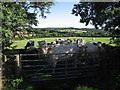
Cattle at Ciliau-Hwnt
Perhaps it was milking time - they were queueing up at the field gate.
Image: © Rudi Winter
Taken: 10 Aug 2010
0.07 miles
2
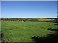
Cattle pasture, near Ciliau-Hwnt
The field is next to the minor road from Llangrannog to Cwmtydu, on the coastal ridge separating Cardigan bay from the entrenched valley of the Nant Fothau.
Image: © Rudi Winter
Taken: 10 Aug 2010
0.12 miles
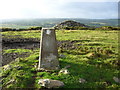
3
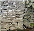
Ordnance Survey Cut Mark
This OS cut mark can be found on the barn at Ciliau-hwnt SE side of the road. It marks a point 165.054m above mean sea level.
Image: © Adrian Dust
Taken: 26 May 2021
0.15 miles
4
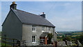
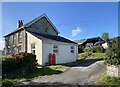
Ciliau-hwnt farm house
A handsome farm house.
Image: © Jeremy Bolwell
Taken: 26 Jul 2014
0.17 miles
6
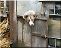
Inquisitive Dog at Troed-y-rhiw-fach Farm
Image: © Anthony Parkes
Taken: 27 Mar 2016
0.23 miles