IMAGES TAKEN NEAR TO
Llwynon, LLANDYSUL, SA44 6BD
Introduction
This page details the photographs taken nearby to Llwynon, SA44 6BD by members of the Geograph project.
The Geograph project started in 2005 with the aim of publishing, organising and preserving representative images for every square kilometre of Great Britain, Ireland and the Isle of Man.

There are currently over 7.5m images from over14,400 individuals and you can help contribute to the project by visiting https://www.geograph.org.uk
Image Map (Loading...)


Getting Data...Please wait
Leaflet Map data © OpenStreetMap
Images are licensed for reuse under creativecommons.org/licenses/by-sa/2.0
Notes
- Clicking on the map will re-center to the selected point.
- The higher the marker number, the further away the image location is from the centre of the postcode.
Image Listing (6 Images Found)
Images are licensed for reuse under creativecommons.org/licenses/by-sa/2.0
Image
Details
Distance
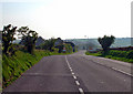
4
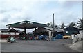
Army Surplus store at Sarnau
Always interesting to brows and shop at. Its amazing what is in these places.
Image: © Jeremy Bolwell
Taken: 3 Mar 2019
0.11 miles
6
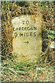
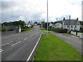
Old Milestone by the A487, west of Sarnau, Penbryn parish
Cardigan low profile top by the A487, in parish of Penbryn (Ceredigion District), West of Sarnau village, in bank, South side of road.
Inscription reads:
TO
CARDIGAN
9 MILES
{arrow->}
Grade II listed by Cadw.
Reference Number: 16094 https://cadwpublic-api.azurewebsites.net/reports/listedbuilding/FullReport?lang=&id=16094
Milestone Society National ID: CRD_CAAY09
Image: © Milestone Society
Taken: Unknown
0.22 miles