IMAGES TAKEN NEAR TO
Llangrannog, LLANDYSUL, SA44 6AZ
Introduction
This page details the photographs taken nearby to SA44 6AZ by members of the Geograph project.
The Geograph project started in 2005 with the aim of publishing, organising and preserving representative images for every square kilometre of Great Britain, Ireland and the Isle of Man.

There are currently over 7.5m images from over14,400 individuals and you can help contribute to the project by visiting https://www.geograph.org.uk
Image Map (Loading...)


Getting Data...Please wait
Leaflet Map data © OpenStreetMap
Images are licensed for reuse under creativecommons.org/licenses/by-sa/2.0
Notes
- Clicking on the map will re-center to the selected point.
- The higher the marker number, the further away the image location is from the centre of the postcode.
Image Listing (5 Images Found)
Images are licensed for reuse under creativecommons.org/licenses/by-sa/2.0
Image
Details
Distance
1
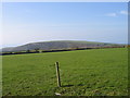
Cae Porfa ger Llain Wen, Llangrannog / Grazing Field near Llain Wen, Llangrannog
Cae Porfa gyda ffens trydan gyda golygfa draw i Langrannog / Grazing Field with an electric fence and distant view to Llangrannog
Image: © Ian Medcalf
Taken: 20 Apr 2007
0.14 miles
2
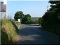
Two ways to Llangrannog
The road to the right is for buses, lorries and caravan as the direct way ahead is very steep and has a dangerous bend.
Image: © Eirian Evans
Taken: 12 Jul 2013
0.17 miles
3
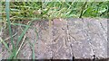
Ordnance Survey Rivet
This OS rivet can be found on the wall SW side of the road. It marks a point 149.044m above mean sea level.
Image: © Adrian Dust
Taken: 1 Jul 2021
0.18 miles
4
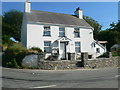
Nantyparac - house on the crossroads
Where the B4434 crosses the road to Pontgarreg
Image: © Eirian Evans
Taken: 11 Jul 2013
0.19 miles
5
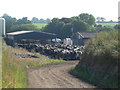
Cattle penned at Nantybach Farm
Waiting to be milked, perhaps
Image: © Eirian Evans
Taken: 11 Jul 2013
0.23 miles