IMAGES TAKEN NEAR TO
Llangrannog, LLANDYSUL, SA44 6AQ
Introduction
This page details the photographs taken nearby to SA44 6AQ by members of the Geograph project.
The Geograph project started in 2005 with the aim of publishing, organising and preserving representative images for every square kilometre of Great Britain, Ireland and the Isle of Man.

There are currently over 7.5m images from over14,400 individuals and you can help contribute to the project by visiting https://www.geograph.org.uk
Image Map (Loading...)


Getting Data...Please wait
Leaflet Map data © OpenStreetMap
Images are licensed for reuse under creativecommons.org/licenses/by-sa/2.0
Notes
- Clicking on the map will re-center to the selected point.
- The higher the marker number, the further away the image location is from the centre of the postcode.
Image Listing (5 Images Found)
Images are licensed for reuse under creativecommons.org/licenses/by-sa/2.0
Image
Details
Distance
1
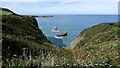
Rocks in the Sea
Perfect spot for sea birds to rest between feeds.
Image: © Sandy Gerrard
Taken: 13 Sep 2022
0.20 miles
2
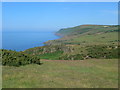
View from near Llangrannog Urdd Centre
Looking northeast along the Cardigan coast.
Image: © Eirian Evans
Taken: 11 Jul 2013
0.20 miles
3
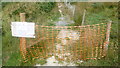
The Wales Coast Path closed due to a landslip in July 2014
A landslip has resulted in the WCP being temporarily closed. I'm sure some intrepid walkers by pass this sign, but we didn't - my safety is paramount. I'm also interested to see what effect on the flora and fauna a closure would have on the path at this time of year.
Image: © Jeremy Bolwell
Taken: 26 Jul 2014
0.24 miles
4
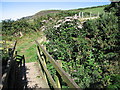
Footbridge on the Ceredigion coast path
Near the Urdd Centre http://www.geograph.org.uk/photo/2017561 at Llangrannog.
Image: © Rudi Winter
Taken: 10 Aug 2010
0.24 miles
5
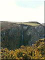
Waterfall into the sea - Ceredigion Coast Path
Image: © Anthony Parkes
Taken: 27 Mar 2016
0.25 miles