IMAGES TAKEN NEAR TO
Velindre, LLANDYSUL, SA44 5XA
Introduction
This page details the photographs taken nearby to SA44 5XA by members of the Geograph project.
The Geograph project started in 2005 with the aim of publishing, organising and preserving representative images for every square kilometre of Great Britain, Ireland and the Isle of Man.

There are currently over 7.5m images from over14,400 individuals and you can help contribute to the project by visiting https://www.geograph.org.uk
Image Map (Loading...)


Getting Data...Please wait
Leaflet Map data © OpenStreetMap
Images are licensed for reuse under creativecommons.org/licenses/by-sa/2.0
Notes
- Clicking on the map will re-center to the selected point.
- The higher the marker number, the further away the image location is from the centre of the postcode.
Image Listing (5 Images Found)
Images are licensed for reuse under creativecommons.org/licenses/by-sa/2.0
Image
Details
Distance
1
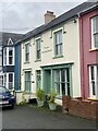
Drefelin village street
Everyday living.
Image: © Dawn Faith Worrall
Taken: 21 Feb 2007
0.06 miles
2
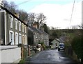
Llwybr yn Nrefelin / A footpath at Drefelin
Cerddwyr yn dilyn llwybr cyhoeddus yn Nrefelin.
Walkers following a public footpath at Drefelin (trans. homestead of the mill).
Image: © Alan Richards
Taken: 6 Feb 2011
0.10 miles
3
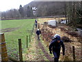
Public Footpath
Through the trees there are views over the villages of Drefelin and Drefach-Velindre.
Image: © Dawn Faith Worrall
Taken: 22 Feb 2007
0.17 miles
4
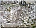
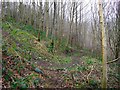
Ordnance Survey Cut Mark
This OS cut mark can be found on the wall of the Old Rectory. It marks a point 68.042m above mean sea level.
Image: © Adrian Dust
Taken: 29 Feb 2020
0.18 miles