IMAGES TAKEN NEAR TO
Industrial Estate, LLANDYSUL, SA44 5TE
Introduction
This page details the photographs taken nearby to Industrial Estate, SA44 5TE by members of the Geograph project.
The Geograph project started in 2005 with the aim of publishing, organising and preserving representative images for every square kilometre of Great Britain, Ireland and the Isle of Man.

There are currently over 7.5m images from over14,400 individuals and you can help contribute to the project by visiting https://www.geograph.org.uk
Image Map (Loading...)


Getting Data...Please wait
Leaflet Map data © OpenStreetMap
Images are licensed for reuse under creativecommons.org/licenses/by-sa/2.0
Notes
- Clicking on the map will re-center to the selected point.
- The higher the marker number, the further away the image location is from the centre of the postcode.
Image Listing (16 Images Found)
Images are licensed for reuse under creativecommons.org/licenses/by-sa/2.0
Image
Details
Distance
1
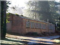
The Former Prisoner of War Camp, Henllan
Image: © Chris Andrews
Taken: 13 Mar 2018
0.03 miles
2
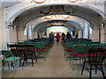
Italian church, Henllan POW camp
Image: © Natasha Ceridwen de Chroustchoff
Taken: 25 Aug 2015
0.06 miles
3
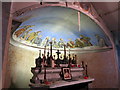
Altar and apse, Italian POW church, Henllan
Image: © Natasha Ceridwen de Chroustchoff
Taken: 25 Aug 2015
0.06 miles
4
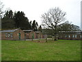
Prisoner of War Camp
Built to house Italian prisoners in the second world war, now used as industrial units.
Image: © Marion Phillips
Taken: 28 Feb 2008
0.07 miles
5
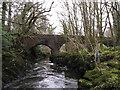
River Teifi and Henllan Bridge
In times of heavy rain the river rises dramatically. Debris suspended from a tree on the right shows a previous high water mark.
Image: © Marion Phillips
Taken: 13 Mar 2008
0.07 miles
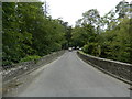
6
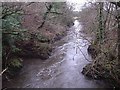
View from Henllan bridge
Looking towards Newcastle Emlyn
Image: © John Gillibrand
Taken: 16 Jan 2006
0.08 miles
7
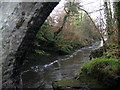
Afon Teifi / Teifi River
Afon Teifi o Bont Henllan.
The River Teifi from Henllan Bridge (trans. old church).
Image: © Alan Richards
Taken: 6 Jan 2008
0.08 miles
8
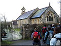
Eglwys Henllan / Henllan Church
Ailadeiladwyd Eglwys Dewi Sant yn 1810 ac eto yn 1849 ar safle lle bu eglwys gynt. Fe'i hailadeilawyd yn rhannol yn 1881.
St Davids was rebuilt in 1810 and again in 1849 on the site of an earlier church. It was again partially rebuilt in 1881.
Image: © Alan Richards
Taken: 6 Jan 2008
0.09 miles
10

Ordnance Survey Rivet
This OS rivet can be found on the NE parapet of Pont Henllan. It marks a point 40.608m above mean sea level.
Image: © Adrian Dust
Taken: 24 May 2023
0.11 miles