IMAGES TAKEN NEAR TO
Rhydlewis, LLANDYSUL, SA44 5SR
Introduction
This page details the photographs taken nearby to SA44 5SR by members of the Geograph project.
The Geograph project started in 2005 with the aim of publishing, organising and preserving representative images for every square kilometre of Great Britain, Ireland and the Isle of Man.

There are currently over 7.5m images from over14,400 individuals and you can help contribute to the project by visiting https://www.geograph.org.uk
Image Map
Images are licensed for reuse under creativecommons.org/licenses/by-sa/2.0
Notes
- Clicking on the map will re-center to the selected point.
- The higher the marker number, the further away the image location is from the centre of the postcode.
Image Listing (2 Images Found)
Images are licensed for reuse under creativecommons.org/licenses/by-sa/2.0
Image
Details
Distance
1
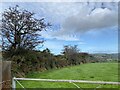
Cwm Hwydrew
Footpath across farmland at Cwm Hwydrew.
Image: © Alan Hughes
Taken: 7 Oct 2024
0.12 miles
2
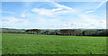
What a difference a day makes!
Looking down towards Pant yr Holiad in very different weather from Image In early October 2007, the weather here alternated between glorious bright sunny days and miserable damp drizzly ones - perhaps typical of the area?
Image: © Zorba the Geek
Taken: 4 Oct 2007
0.14 miles