IMAGES TAKEN NEAR TO
Rhydlewis, LLANDYSUL, SA44 5PG
Introduction
This page details the photographs taken nearby to SA44 5PG by members of the Geograph project.
The Geograph project started in 2005 with the aim of publishing, organising and preserving representative images for every square kilometre of Great Britain, Ireland and the Isle of Man.

There are currently over 7.5m images from over14,400 individuals and you can help contribute to the project by visiting https://www.geograph.org.uk
Image Map
Images are licensed for reuse under creativecommons.org/licenses/by-sa/2.0
Notes
- Clicking on the map will re-center to the selected point.
- The higher the marker number, the further away the image location is from the centre of the postcode.
Image Listing (8 Images Found)
Images are licensed for reuse under creativecommons.org/licenses/by-sa/2.0
Image
Details
Distance
4
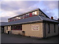
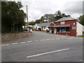
Siop y Bont
Village stores and post office constructed of timber and corrugated sheets.
Image: © Marion Phillips
Taken: 21 Jan 2011
0.17 miles
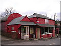
5

Ordnance Survey Cut Mark
This OS cut mark can be found on the west parapet of the bridge. It marks a point 108.271m above mean sea level.
Image: © Adrian Dust
Taken: 1 Jul 2021
0.17 miles
6
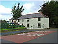
Bwlchgwyn, Rhydlewis
This appears to be the current name, but the building was once a pub: the Gwern-nant Arms. The Calvinistic "Cardigan and Tivy-side Advertiser" wrote in 1915: "The dreams of the inhabitants of the Rhydlewis valley have now been realised, and this place is now clear from an inn, as the sign of the Gwernant Arms has been taken down." The campaign for its closure was led by the local Methodist minister.
Image: © Dylan Moore
Taken: 3 Oct 2008
0.23 miles