IMAGES TAKEN NEAR TO
Cae Rwgan, Aberbanc, LLANDYSUL, SA44 5NQ
Introduction
This page details the photographs taken nearby to Cae Rwgan, Aberbanc, SA44 5NQ by members of the Geograph project.
The Geograph project started in 2005 with the aim of publishing, organising and preserving representative images for every square kilometre of Great Britain, Ireland and the Isle of Man.

There are currently over 7.5m images from over14,400 individuals and you can help contribute to the project by visiting https://www.geograph.org.uk
Image Map
Images are licensed for reuse under creativecommons.org/licenses/by-sa/2.0
Notes
- Clicking on the map will re-center to the selected point.
- The higher the marker number, the further away the image location is from the centre of the postcode.
Image Listing (9 Images Found)
Images are licensed for reuse under creativecommons.org/licenses/by-sa/2.0
Image
Details
Distance
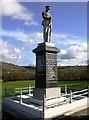
1
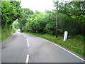
A475 and B4334 junction
The A475 takes an extraordinary sidestep in Aber-banc to facilitate crossing the steep sided valley of Afon Cynllo. The road's situation is complicated by its junction with the B4334. It's a case where less velocity for the velocipede is better than more!
Image: © Stuart Logan
Taken: 5 Oct 2011
0.14 miles
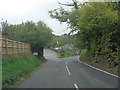
2
Aberbanc
Junction of Newcastle Emlyn and Henllan roads.
Image: © John Duckfield
Taken: 8 Jun 2009
0.16 miles
4
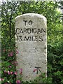
Old Milestone by the A475, Aber-banc, Llandyfriog parish
Cardigan tombstone by the A475, in parish of Llandyfriog (Ceredigion District), near Aber-banc.
Inscription reads:-
TO
CARDIGAN
13 MILES
Carved benchmark on lower face.
Grade II listed by Cadw.
Reference Number: 17592 https://cadwpublic-api.azurewebsites.net/reports/listedbuilding/FullReport?lang=&id=17592
Surveyed
Milestone Society National ID: CRD_CALA13
Image: © Milestone Society
Taken: Unknown
0.19 miles
5
Ordnance Survey Cut Mark
This OS cut mark can be found on the house which was once the Aber Banc Stores. It marks a point 77.461m above mean sea level.
Image: © Adrian Dust
Taken: 29 Feb 2020
0.19 miles
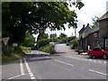
6
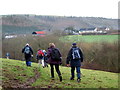
Tuag at Aberbanc / Towards Aberbanc
Cerddwyr yn dilyn llwybr cyhoeddus tuag at bentre Aberbanc.
Walkers following a public footpath towards the village of Aberbanc.
Image: © Alan Richards
Taken: 6 Jan 2008
0.19 miles
7
Milestone - Cardigan 13
The OS cut mark on the stone marks a point 87.888m above mean sea level.
Image: © Adrian Dust
Taken: 29 Feb 2020
0.20 miles
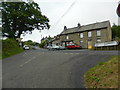
8
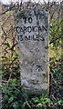
Milestone at Aberbanc
The milestone states "Cardigan 13" and also has a benchmark on it. The A475 descends steeply here before crossing Afon Cynllo.
Image: © Marion Phillips
Taken: 2 Jul 2009
0.22 miles