IMAGES TAKEN NEAR TO
Maesllyn, LLANDYSUL, SA44 5ND
Introduction
This page details the photographs taken nearby to SA44 5ND by members of the Geograph project.
The Geograph project started in 2005 with the aim of publishing, organising and preserving representative images for every square kilometre of Great Britain, Ireland and the Isle of Man.

There are currently over 7.5m images from over14,400 individuals and you can help contribute to the project by visiting https://www.geograph.org.uk
Image Map
Images are licensed for reuse under creativecommons.org/licenses/by-sa/2.0
Notes
- Clicking on the map will re-center to the selected point.
- The higher the marker number, the further away the image location is from the centre of the postcode.
Image Listing (3 Images Found)
Images are licensed for reuse under creativecommons.org/licenses/by-sa/2.0
Image
Details
Distance
1
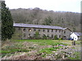
Maesllyn Mill
This is one of many woollen mills in this area that has closed in the last century. The abundant local sheep produced wool and the fast flowing streams drove water wheels to provide energy for the many parts of the production process in these mills. After it closed, this mill became a woollen mill museum and housed many interesting exhibits as well as working machinery. It is now privately owned and no longer open to the public.
Image: © Marion Phillips
Taken: 20 Apr 2008
0.14 miles
2
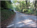
Heol fynedfa Ffarm Gernos / Gernos Farm access road
Heol fynedfa yn arwain at Farm Gernos ac anhedd-dai eraill.
An access road leading to Gernos Farm and other properties.
Image: © Alan Richards
Taken: 18 Sep 2019
0.23 miles
3
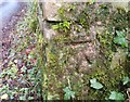
Ordnance Survey Cut Mark
This OS cut mark can be found on the gatepost NE side of the road. It marks a point 178.765m above mean sea level.
Image: © Adrian Dust
Taken: 29 Feb 2020
0.24 miles