IMAGES TAKEN NEAR TO
Rhos, LLANDYSUL, SA44 5EQ
Introduction
This page details the photographs taken nearby to SA44 5EQ by members of the Geograph project.
The Geograph project started in 2005 with the aim of publishing, organising and preserving representative images for every square kilometre of Great Britain, Ireland and the Isle of Man.

There are currently over 7.5m images from over14,400 individuals and you can help contribute to the project by visiting https://www.geograph.org.uk
Image Map
Images are licensed for reuse under creativecommons.org/licenses/by-sa/2.0
Notes
- Clicking on the map will re-center to the selected point.
- The higher the marker number, the further away the image location is from the centre of the postcode.
Image Listing (14 Images Found)
Images are licensed for reuse under creativecommons.org/licenses/by-sa/2.0
Image
Details
Distance
1
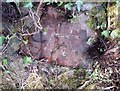
Ordnance Survey Cut Mark
This OS cut mark can be found on the wall at the entrance to Rhosgeler Farm. It marks a point 236.904m above mean sea level.
Image: © Adrian Dust
Taken: 8 Nov 2019
0.09 miles
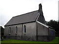
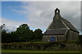
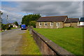
6
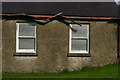
Rhos Evangelical Church (detail)
Image: © Christopher Hilton
Taken: 24 Aug 2010
0.17 miles
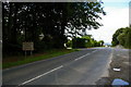
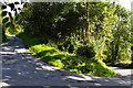
7
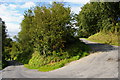
Rhos: road down to Nant-y-Bargoed, top hairpin
Image: © Christopher Hilton
Taken: 24 Aug 2010
0.17 miles
8
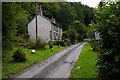
Nant Bargoed: converted weaver's cottage
Image: © Christopher Hilton
Taken: 22 Aug 2010
0.18 miles
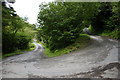
9
Rhos: road down to Nant-y-Bargoed, middle hairpin
Image: © Christopher Hilton
Taken: 24 Aug 2010
0.18 miles
10
Rhos: road down to Nant-y-Bargoed, bottom hairpin
Image: © Christopher Hilton
Taken: 22 Aug 2010
0.19 miles