IMAGES TAKEN NEAR TO
Saron, LLANDYSUL, SA44 5EA
Introduction
This page details the photographs taken nearby to SA44 5EA by members of the Geograph project.
The Geograph project started in 2005 with the aim of publishing, organising and preserving representative images for every square kilometre of Great Britain, Ireland and the Isle of Man.

There are currently over 7.5m images from over14,400 individuals and you can help contribute to the project by visiting https://www.geograph.org.uk
Image Map
Images are licensed for reuse under creativecommons.org/licenses/by-sa/2.0
Notes
- Clicking on the map will re-center to the selected point.
- The higher the marker number, the further away the image location is from the centre of the postcode.
Image Listing (3 Images Found)
Images are licensed for reuse under creativecommons.org/licenses/by-sa/2.0
Image
Details
Distance
1
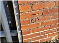
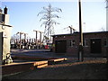
Ordnance Survey Cut Mark
This OS cut mark can be found on the Electricity Sub-Station. It marks a point 182.887m above mean sea level.
Image: © Adrian Dust
Taken: 8 Nov 2019
0.16 miles
2
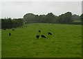
Black sheep
A flock of black Welsh mountain sheep grazing on a gloomy day. On the far side of the A484, hidden behind the hedge, you can see some goalposts on the Saron playing fields.
Image: © Marion Phillips
Taken: 21 Jul 2009
0.16 miles