IMAGES TAKEN NEAR TO
Pentre-Cwrt, LLANDYSUL, SA44 5AT
Introduction
This page details the photographs taken nearby to SA44 5AT by members of the Geograph project.
The Geograph project started in 2005 with the aim of publishing, organising and preserving representative images for every square kilometre of Great Britain, Ireland and the Isle of Man.

There are currently over 7.5m images from over14,400 individuals and you can help contribute to the project by visiting https://www.geograph.org.uk
Image Map
Images are licensed for reuse under creativecommons.org/licenses/by-sa/2.0
Notes
- Clicking on the map will re-center to the selected point.
- The higher the marker number, the further away the image location is from the centre of the postcode.
Image Listing (7 Images Found)
Images are licensed for reuse under creativecommons.org/licenses/by-sa/2.0
Image
Details
Distance
1
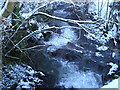
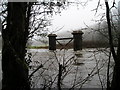
Afon Siedi
Winter view from the bridge.
Image: © Marion Phillips
Taken: 2 Jan 2010
0.09 miles
2
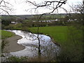
River Teifi and Pentrecwrt
The river is meandering in this part of its valley before passing through the rocky gorge at Allt-y-cafan. Some of the village of Pentrecwrt, strung out along the main A486 road, can be seen beyond. On the extreme left is a sewage treatment works, hidden from the view of the people of Pentrecwrt by the evergreen trees.
Image: © Marion Phillips
Taken: 15 Apr 2008
0.19 miles
5
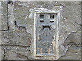
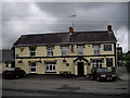
Ordnance Survey Flush Bracket S0434
This can be found of a derelict and unused building - the former Post Office.
For more detail see : http://www.bench-marks.org.uk/log?bm_key=20588
Image: © Peter Wood
Taken: 23 May 2013
0.22 miles
6
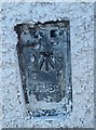
Ordnance Survey Flush Bracket (S0434)
This OS Flush Bracket can be found on the former Post Office. It marks a point 63.122m above mean sea level.
Image: © Adrian Dust
Taken: 8 Nov 2019
0.23 miles
7
Railway bridge?
The Newcastle Emlyn branch of the Great Western Railway was closed completely in 1973 and the bridge was demolished in about 2006.
Image: © Marion Phillips
Taken: 15 Jan 2011
0.23 miles