IMAGES TAKEN NEAR TO
Pontsian, LLANDYSUL, SA44 4TU
Introduction
This page details the photographs taken nearby to SA44 4TU by members of the Geograph project.
The Geograph project started in 2005 with the aim of publishing, organising and preserving representative images for every square kilometre of Great Britain, Ireland and the Isle of Man.

There are currently over 7.5m images from over14,400 individuals and you can help contribute to the project by visiting https://www.geograph.org.uk
Image Map (Loading...)


Getting Data...Please wait
Leaflet Map data © OpenStreetMap
Images are licensed for reuse under creativecommons.org/licenses/by-sa/2.0
Notes
- Clicking on the map will re-center to the selected point.
- The higher the marker number, the further away the image location is from the centre of the postcode.
Image Listing (8 Images Found)
Images are licensed for reuse under creativecommons.org/licenses/by-sa/2.0
Image
Details
Distance
2
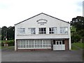
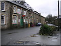
Neuadd Coffa
Neuadd Coffa in Pont-Sian on the B4459.
Image: © Cered
Taken: 20 Sep 2005
0.12 miles
4
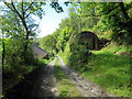
Llwybr Ceffyl Pont-Sian / Pont-Sian Bridleway
Llwybr ceffyl yn mynd heibio i anhedd-dy wrth agosau at bentre Pont-Sian.
A bridleway passing a property as it descends towards the village of Pont-Sian (trans. Sian's bridge).
Image: © Alan Richards
Taken: 12 May 2019
0.13 miles
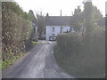
5
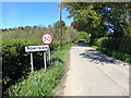
Cyrraedd Ponsian / Arriving at Pontsian
Cyrraedd pentre Pontsian.
Entering the village of Pontsian (trans. Sian's bridge).
Image: © Alan Richards
Taken: 12 May 2019
0.15 miles
6
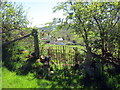
Llwybr ger Heol-feinog / Path near Heol-feinog
Llwybr cyhoeddus ger Ffarm Heol-feinog.
A public footpath near Heol-feinog Farm (trans. stony road).
Image: © Alan Richards
Taken: 12 May 2019
0.20 miles
7
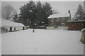
Heolfeinog in the snow
Taken during the snowfall of 9th February, 2007
Image: © Sara Jones
Taken: 9 Feb 2007
0.23 miles