IMAGES TAKEN NEAR TO
Ffostrasol, LLANDYSUL, SA44 4TJ
Introduction
This page details the photographs taken nearby to SA44 4TJ by members of the Geograph project.
The Geograph project started in 2005 with the aim of publishing, organising and preserving representative images for every square kilometre of Great Britain, Ireland and the Isle of Man.

There are currently over 7.5m images from over14,400 individuals and you can help contribute to the project by visiting https://www.geograph.org.uk
Image Map (Loading...)


Getting Data...Please wait
Leaflet Map data © OpenStreetMap
Images are licensed for reuse under creativecommons.org/licenses/by-sa/2.0
Notes
- Clicking on the map will re-center to the selected point.
- The higher the marker number, the further away the image location is from the centre of the postcode.
Image Listing (6 Images Found)
Images are licensed for reuse under creativecommons.org/licenses/by-sa/2.0
Image
Details
Distance
1
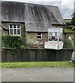
Gabrielle's Galley
Art gallery with workshops off the A486 between Ffostrasol and Capel Cynon
Image: © Eirian Evans
Taken: 25 Sep 2022
0.08 miles
4
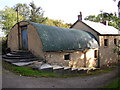
Farm building, Capel Cynon, Llandissiliogogo
Quite an unusual building. Note the concrete steps, especially the semi-circular ones.
Image: © Humphrey Bolton
Taken: 30 Sep 2007
0.25 miles
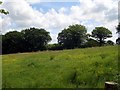
5
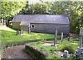
Capel Cynon, Llandissiliogogo
Map-reading required! This church cannot be seen from the road and there is no signpost.
Image: © Humphrey Bolton
Taken: 30 Sep 2007
0.25 miles
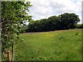
6
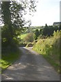
The lane through Capel Cynon, Llandissiliogogo
Looking down towards the main road.
Image: © Humphrey Bolton
Taken: 30 Sep 2007
0.25 miles