IMAGES TAKEN NEAR TO
Panteg Cross, LLANDYSUL, SA44 4SL
Introduction
This page details the photographs taken nearby to SA44 4SL by members of the Geograph project.
The Geograph project started in 2005 with the aim of publishing, organising and preserving representative images for every square kilometre of Great Britain, Ireland and the Isle of Man.

There are currently over 7.5m images from over14,400 individuals and you can help contribute to the project by visiting https://www.geograph.org.uk
Image Map
Images are licensed for reuse under creativecommons.org/licenses/by-sa/2.0
Notes
- Clicking on the map will re-center to the selected point.
- The higher the marker number, the further away the image location is from the centre of the postcode.
Image Listing (3 Images Found)
Images are licensed for reuse under creativecommons.org/licenses/by-sa/2.0
Image
Details
Distance
1
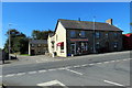
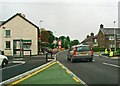
Siop y pentre, Croes-lan/ Croes-lan village stores
Siop y pentre ar groesffordd yng Nghroes-lan.
The village stores at a crossroads in Croes-lan (trans. 'parish crossroads' according to the Dictionary of Place Names in Wales).
Image: © Alan Richards
Taken: 18 Sep 2019
0.09 miles