IMAGES TAKEN NEAR TO
Charles Street, LLANDYSUL, SA44 4QW
Introduction
This page details the photographs taken nearby to Charles Street, SA44 4QW by members of the Geograph project.
The Geograph project started in 2005 with the aim of publishing, organising and preserving representative images for every square kilometre of Great Britain, Ireland and the Isle of Man.

There are currently over 7.5m images from over14,400 individuals and you can help contribute to the project by visiting https://www.geograph.org.uk
Image Map
Images are licensed for reuse under creativecommons.org/licenses/by-sa/2.0
Notes
- Clicking on the map will re-center to the selected point.
- The higher the marker number, the further away the image location is from the centre of the postcode.
Image Listing (36 Images Found)
Images are licensed for reuse under creativecommons.org/licenses/by-sa/2.0
Image
Details
Distance
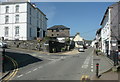
2
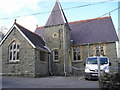
Former Peniel Wesleyan Methodist Chapel, Llandysul
This is now a youth club. 'The Buildings of Wales' states that it was built in 1844 and 1902, and the shelter across the front was added in 1999.
Image: © Humphrey Bolton
Taken: 21 Apr 2019
0.03 miles
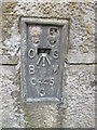
3
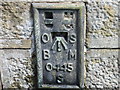
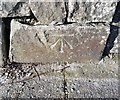
Ordnance Survey Flush Bracket S0445
This can be found on a gatepost in Seion Hill.
For more detail see : http://www.bench-marks.org.uk/log?bm_key=20586
Image: © Peter Wood
Taken: 23 May 2013
0.04 miles
4
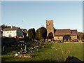
St Tysul Church, Llandysul
Church and churchyard
Image: © Nigel Callaghan
Taken: 9 Nov 2005
0.04 miles
5
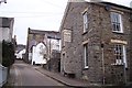
King Street and Richmond House, Llandysul
In 'The Buildings of Wales' Richmond House is described as "a surprisingly grand double villa in stucco of c.1870-80, more coastal resort than mid-Wales."
Image: © Humphrey Bolton
Taken: 21 Apr 2019
0.04 miles
6
Ordnance Survey Flush Bracket (S0445)
This OS Flush Bracket can be found on the south face of Seion Hill. It marks a point 79.233m above mean sea level.
Image: © Adrian Dust
Taken: 12 Mar 2015
0.04 miles
7
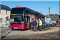
Stranded at Llandysul!
Adventure Coachlines operate the once a day T1c (TrawsCymru) service from Aberystwyth to Cardiff. Unfortunately, on the day that I chose to use it, the coach came to a halt at Llandysul and could go no further. An air leak prevented the doors from closing, so it was immobilised. A local mechanic was summoned, but he was unable to fix the problem. Eventually, after a three-hour wait, a replacement coach arrived from Aberystwyth. Looking on the bright side, I was able to score a Geograph personal point as I have previously driven through Llandysul but never stopped there!
Image: © John Lucas
Taken: 7 Feb 2023
0.05 miles
8
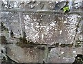
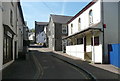
Ordnance Survey Cut Mark
This OS cut mark can be found on the wall NW side of Wind Street. It marks a point 73.884m above mean sea level.
Image: © Adrian Dust
Taken: 8 Nov 2019
0.05 miles
10
Ordnance Survey Cut Mark
This OS cut mark can be found on a gatepost west side of Church Street. It marks a point 66.959m above mean sea level.
Image: © Adrian Dust
Taken: 8 Nov 2019
0.06 miles