IMAGES TAKEN NEAR TO
Tregroes, LLANDYSUL, SA44 4NS
Introduction
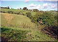
This page details the photographs taken nearby to SA44 4NS by members of the Geograph project.
The Geograph project started in 2005 with the aim of publishing, organising and preserving representative images for every square kilometre of Great Britain, Ireland and the Isle of Man.

There are currently over 7.5m images from over14,400 individuals and you can help contribute to the project by visiting https://www.geograph.org.uk
Image Map (Loading...)


Getting Data...Please wait
Leaflet Map data © OpenStreetMap
Images are licensed for reuse under creativecommons.org/licenses/by-sa/2.0
Notes
- Clicking on the map will re-center to the selected point.
- The higher the marker number, the further away the image location is from the centre of the postcode.
Image Listing (7 Images Found)
Images are licensed for reuse under creativecommons.org/licenses/by-sa/2.0
Image
Details
Distance
6
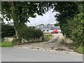
Winch Farm
Large house in a small hamlet
Image: © Eirian Evans
Taken: 27 Aug 2023
0.18 miles
7
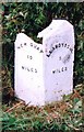
Old Milestone by the A486, Bwlch-y-groes, Troedyraur parish
Newquay flat top casting by the A486, in parish of Troedyraur (Ceredigion District), Bwlch-y-groes, 300m North of Bwlch-y-groes crossroads. Broken on top.
Inscription reads:-
: NEW QUAY / 10 / MILES : : LLANDYSSUL / 5 / MILES :
Grade II listed by Cadw.
Reference Number: 17618 https://cadwpublic-api.azurewebsites.net/reports/listedbuilding/FullReport?lang=&id=17618
Surveyed
Milestone Society National ID: CRD_NQLD10
Image: © Milestone Society
Taken: Unknown
0.18 miles