IMAGES TAKEN NEAR TO
Pencader Road, LLANDYSUL, SA44 4AE
Introduction
This page details the photographs taken nearby to Pencader Road, SA44 4AE by members of the Geograph project.
The Geograph project started in 2005 with the aim of publishing, organising and preserving representative images for every square kilometre of Great Britain, Ireland and the Isle of Man.

There are currently over 7.5m images from over14,400 individuals and you can help contribute to the project by visiting https://www.geograph.org.uk
Image Map
Images are licensed for reuse under creativecommons.org/licenses/by-sa/2.0
Notes
- Clicking on the map will re-center to the selected point.
- The higher the marker number, the further away the image location is from the centre of the postcode.
Image Listing (11 Images Found)
Images are licensed for reuse under creativecommons.org/licenses/by-sa/2.0
Image
Details
Distance
1
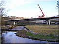
Llandysul Bypass
A raised section of the new bypass under construction, seen here crossing the Afon Tyweli. The upper part of Llandysul can be seen beyond.
Image: © Marion Phillips
Taken: 4 Mar 2009
0.12 miles
2
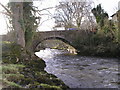
Llandysul Bridge
The River Teifi flowing swiftly under the road bridge.
Image: © Marion Phillips
Taken: 4 Feb 2008
0.12 miles
3
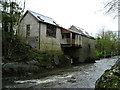
The Power House
The Power House provided electricity for the whole area of Llandysul from the year 1920. It took water from the River Teifi to power its generators. It is now used as a community centre for cultural and artistic activities.
This fast flowing stretch of river is used for canoeing including slalom events.
Image: © Marion Phillips
Taken: 30 Apr 2008
0.12 miles
4
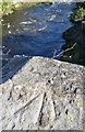
Ordnance Survey Rivet
This OS rivet can be found on the NE parapet of Llandysul Bridge. It marks a point 61.714m above mean sea level.
Image: © Adrian Dust
Taken: 8 Nov 2019
0.13 miles
5
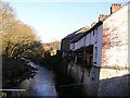
Riverside Houses
Residents of these old houses beside the River Teifi can get a grandstand view of the canoeing activity down below. Beyond the houses is the Fedwen Mill, now used as a bakery.
Image: © Marion Phillips
Taken: 9 Jan 2009
0.14 miles
6
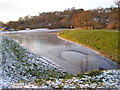
Canoeing lake
A recently created artificial lake for canoeing activities, frozen over except for the part by the water inflow.
Image: © Marion Phillips
Taken: 1 Dec 2010
0.18 miles
7
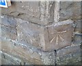
Ordnance Survey Cut Mark
This OS cut mark can be found on the Half Moon. It marks a point 59.278m above mean sea level.
Image: © Adrian Dust
Taken: 8 Nov 2019
0.19 miles
8
Site of former Llandyssul station, 2004
View SE, towards Pencader: ex-GWR Pencader - Newcastle Emlyn branch. Passenger services on the branch ceased from 15/9/52, goods not until 22/9/73 (Llandyssul from 5/9/65). In 2004 the site was in commercial use, but in more recent years it has been incorporated in a great new Llandyssul by-pass.
Image: © Ben Brooksbank
Taken: 25 Jun 2004
0.22 miles
9
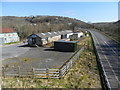
Site of Llandysul Station Yard
The new Llandysul bypass, on the right,goes across the site of Llandysul Station, closed as part of the Beeching Plan. The long building on the left is all that is left of the station's goods facilities. Sidings ran alongside and wagons were unloaded directly into them.
Image: © Simon Parsons
Taken: 11 Mar 2013
0.22 miles
10
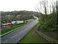
Llandysul bypass
The newly completed bypass is now open.
Image: © Marion Phillips
Taken: 8 Dec 2009
0.24 miles