IMAGES TAKEN NEAR TO
Blodwen Terrace, SWANSEA, SA4 3XU
Introduction
This page details the photographs taken nearby to Blodwen Terrace, SA4 3XU by members of the Geograph project.
The Geograph project started in 2005 with the aim of publishing, organising and preserving representative images for every square kilometre of Great Britain, Ireland and the Isle of Man.

There are currently over 7.5m images from over14,400 individuals and you can help contribute to the project by visiting https://www.geograph.org.uk
Image Map (Loading...)


Getting Data...Please wait
Leaflet Map data © OpenStreetMap
Images are licensed for reuse under creativecommons.org/licenses/by-sa/2.0
Notes
- Clicking on the map will re-center to the selected point.
- The higher the marker number, the further away the image location is from the centre of the postcode.
Image Listing (27 Images Found)
Images are licensed for reuse under creativecommons.org/licenses/by-sa/2.0
Image
Details
Distance
1
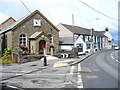
Pen-clawdd
Chapel, cafe and cottages line the street approaching the tidal estuary of the Loughor.
Image: © Colin Smith
Taken: 24 Jul 2009
0.01 miles
2
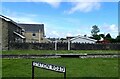
Remains of the Penclawdd Railway Platform
Built as a branch of the Llanelli Railway & Dock Company. Freight and passenger services used the line, passengers changing at Gowerton for Swansea. It used to be really busy with coal traffic but as coal mining declined and a new road was built from Gowerton to Llanrhidian in the 1920's, passenger numbers declined and the service was stopped apart from daily freight services.
Image: © Eirian Evans
Taken: 21 May 2022
0.03 miles
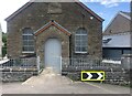
5
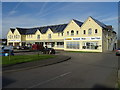
Nisa Extra Supermarket, Post Office and Barber
Supermarket in Station Road.
Image: © John M
Taken: 1 Nov 2017
0.05 miles
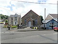
7
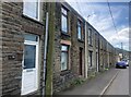
Stone cottages at Pen-Clawdd
Lining the south side of Station Road
Image: © Eirian Evans
Taken: 19 May 2022
0.08 miles

10

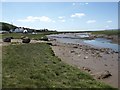
Slipway, Penclawdd
This slipway is all that remains of the canal dock which was built here between 1811-13. Penclawdd Canal was used to transfer coal to sea going vessels. The canal was never successful and closed after a few years.
Image: © Eirian Evans
Taken: 21 May 2022
0.10 miles