IMAGES TAKEN NEAR TO
Penuel, Llanmorlais, SWANSEA, SA4 3UQ
Introduction
This page details the photographs taken nearby to SA4 3UQ by members of the Geograph project.
The Geograph project started in 2005 with the aim of publishing, organising and preserving representative images for every square kilometre of Great Britain, Ireland and the Isle of Man.

There are currently over 7.5m images from over14,400 individuals and you can help contribute to the project by visiting https://www.geograph.org.uk
Image Map
Images are licensed for reuse under creativecommons.org/licenses/by-sa/2.0
Notes
- Clicking on the map will re-center to the selected point.
- The higher the marker number, the further away the image location is from the centre of the postcode.
Image Listing (7 Images Found)
Images are licensed for reuse under creativecommons.org/licenses/by-sa/2.0
Image
Details
Distance
1
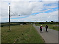
Welsh Moor
Cerddwyr ar gomin Welsh Moor gyda pholyn lamp rhyfedd.
Walkers on a common at Welsh Moor with an unusual street lamp.
Image: © Alan Richards
Taken: 13 Jul 2014
0.04 miles
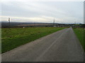
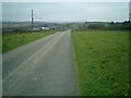
3
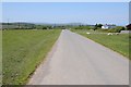
Country road approaching Welsh Moor
An unfenced country road approaching Welsh Moor. The Gower Way follows this road.
Image: © Philip Halling
Taken: 17 May 2014
0.09 miles
4
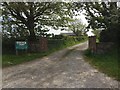
Tir Coch Farm
Entrance to Tir Coch Farm holiday cottages.
Image: © Alan Hughes
Taken: 15 May 2019
0.15 miles
6
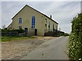
Penuel Chapel
Converted chapel near Llanmorlais.
Image: © Alan Hughes
Taken: 15 May 2019
0.23 miles
7

The Ffarm
The Ffarm, ffermdy uwchlaw pentre Llanmorlais.
A property known as The Farm above Llanmorlais
Image: © Alan Richards
Taken: 2 Jun 1996
0.23 miles