IMAGES TAKEN NEAR TO
Trem Y Mor, SWANSEA, SA4 3TZ
Introduction
This page details the photographs taken nearby to Trem Y Mor, SA4 3TZ by members of the Geograph project.
The Geograph project started in 2005 with the aim of publishing, organising and preserving representative images for every square kilometre of Great Britain, Ireland and the Isle of Man.

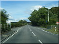
There are currently over 7.5m images from over14,400 individuals and you can help contribute to the project by visiting https://www.geograph.org.uk
Image Map (Loading...)


Getting Data...Please wait
Leaflet Map data © OpenStreetMap
Images are licensed for reuse under creativecommons.org/licenses/by-sa/2.0
Notes
- Clicking on the map will re-center to the selected point.
- The higher the marker number, the further away the image location is from the centre of the postcode.
Image Listing (11 Images Found)
Images are licensed for reuse under creativecommons.org/licenses/by-sa/2.0
Image
Details
Distance
2

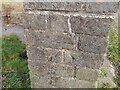
Ordnance Survey Rivet
This OS rivet can be found at the road junction. It marks a point 8.325m above mean sea level.
Image: © Adrian Dust
Taken: 17 Dec 2015
0.18 miles
3
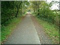
Disused railway track now a cycle path
The railway was opened in 1884 to take coal from local coal mines. It was closed for passengers in 1931 and for freight in 1957 and the track was lifted in 1959/1960.
Image: © Tony Dobbs
Taken: 6 Nov 2008
0.19 miles
4
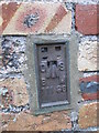
Ordnance Survey Flush Bracket (11186)
This OS cut mark can be found on the barn conversion at Cwm Cynnar Farm. It marks a point 28.874m above mean sea level.
Image: © Adrian Dust
Taken: 17 Dec 2015
0.20 miles
5

Crofty
Cerddwyr yn agosau at bentre Crofty a welir yn y pellter.
Walkers approaching the village of Crofty visible in the distance.
Image: © Alan Richards
Taken: 13 Jul 2014
0.20 miles
6
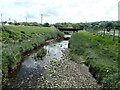
Ordnance Survey Cut Mark
This OS cut mark can be found on the end of the NW parapet of the bridge. It marks a point 5.837m above mean sea level.
Image: © Adrian Dust
Taken: 11 Feb 2022
0.20 miles
8
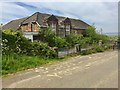
Llanmorlais County School
Nature seems to be swallowing up this old village school which was built in 1893 and was controversially closed in 2010.
Image: © Alan Hughes
Taken: 15 May 2019
0.20 miles

10
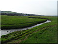
Morlais River
The river flows into Salthouse Pill.
Image: © John M
Taken: 1 Nov 2017
0.22 miles