IMAGES TAKEN NEAR TO
Church Row, SWANSEA, SA4 3TT
Introduction
This page details the photographs taken nearby to Church Row, SA4 3TT by members of the Geograph project.
The Geograph project started in 2005 with the aim of publishing, organising and preserving representative images for every square kilometre of Great Britain, Ireland and the Isle of Man.

There are currently over 7.5m images from over14,400 individuals and you can help contribute to the project by visiting https://www.geograph.org.uk
Image Map (Loading...)


Getting Data...Please wait
Leaflet Map data © OpenStreetMap
Images are licensed for reuse under creativecommons.org/licenses/by-sa/2.0
Notes
- Clicking on the map will re-center to the selected point.
- The higher the marker number, the further away the image location is from the centre of the postcode.
Image Listing (14 Images Found)
Images are licensed for reuse under creativecommons.org/licenses/by-sa/2.0
Image
Details
Distance
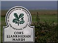
3
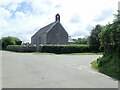
Glimpse of St David?s Church, Wernffrwd
Image: © Alan Hughes
Taken: 28 Oct 2022
0.02 miles
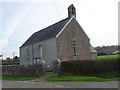
4
St David's Church, Wernffrwd
Situated on the edge of the salt marshes
Image: © Deborah Tilley
Taken: 6 Jun 2015
0.03 miles
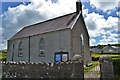
5
St David's Church, Gwernffrwd
A church on the edge of Llanmorlais Marsh, holding weekly Sunday services
Image: © Eirian Evans
Taken: 21 May 2022
0.03 miles
6
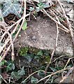
Ordnance Survey Rivet
This OS rivet can be found on the SW parapet of the bridge. It marks a point 7.745m above mean sea level.
Image: © Adrian Dust
Taken: 11 Feb 2022
0.03 miles
9
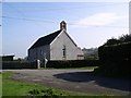
St David's Church, Gwernffrwd
The Ordnance Survey map shows this place as 'Wernffrwd', but the noticeboard outside the church shows 'Gwernffrwd'.
Image: © Chris Henley
Taken: 18 Oct 2006
0.06 miles
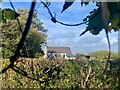
10
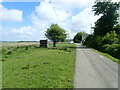
Marsh Road between Llanrhidian and Llanmorlais
The structure to the left of the tree is a mystery
Image: © Eirian Evans
Taken: 21 May 2022
0.12 miles