IMAGES TAKEN NEAR TO
Llwynderw, SWANSEA, SA4 3QG
Introduction
This page details the photographs taken nearby to Llwynderw, SA4 3QG by members of the Geograph project.
The Geograph project started in 2005 with the aim of publishing, organising and preserving representative images for every square kilometre of Great Britain, Ireland and the Isle of Man.

There are currently over 7.5m images from over14,400 individuals and you can help contribute to the project by visiting https://www.geograph.org.uk
Image Map (Loading...)


Getting Data...Please wait
Leaflet Map data © OpenStreetMap
Images are licensed for reuse under creativecommons.org/licenses/by-sa/2.0
Notes
- Clicking on the map will re-center to the selected point.
- The higher the marker number, the further away the image location is from the centre of the postcode.
Image Listing (15 Images Found)
Images are licensed for reuse under creativecommons.org/licenses/by-sa/2.0
Image
Details
Distance
1
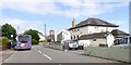
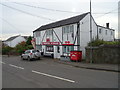
Bus stop opposite the Joiners Arms, Three Crosses
Image: © David Smith
Taken: 2 Jun 2018
0.09 miles
2
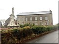
Chapel y Crwys
Independent Congregation non-conformist chapel in Three Crosses.
Image: © Alan Hughes
Taken: 12 Dec 2018
0.10 miles
3
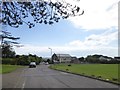
Open space in Three Crosses and Welsh Independent Chapel
The open space is designated as a play area. The chapel dates from 1878 Image
Image: © David Smith
Taken: 2 Jun 2018
0.11 miles
4
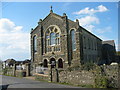
Capel y Crwys, Three Crosses
Capel y Crwys, Addoldy'r Annibynnwyr. Cyn codi'r addoldy cyntaf yn 1788 cwrddai'r aelodau mewn ffarm gyfagos o'r enw Cwm Mawr. Fe'i hailadeiladwyd yn 1831 ac mae'r capel presennol yn dyddio o 1878. Y gwr a'i hadeiladodd oedd y pensaer enwog hwnnw, John Humphries (1819-1888) a gododd Capel Tabernacle, Treforus.
Capel y Crwys, Welsh Independent Chapel at Three Crosses. Prior to building the first chapel in 1788 worshippers met at nearby Cwm Mawr Farm. Rebuilt in 1831 the present chapel was erected in 1878 by that well known architect, John Humphreys who built the impressive Tabernacle Chapel in Morriston.
Image: © Alan Richards
Taken: 10 Oct 2004
0.12 miles
5
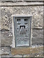
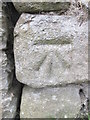
Ordnance Survey Flush Bracket (G3821)
This OS Flush Bracket can be found on the NW face of the school building. It marks a point 127.335m above mean sea level.
Image: © Adrian Dust
Taken: 1 Jun 2014
0.13 miles
6
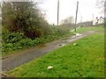
Footpath at Three Crosses
Footpath leading from Dunvant to Three Crosses.
Image: © Alan Hughes
Taken: 12 Dec 2018
0.16 miles
8
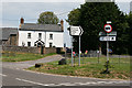
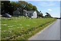
Three Crosses: farmhouse by road junction
Looking north east by the turning to the Gower Golf Club. This is one of the few older farmhouses surviving on Gower and it won a recent Gower Society Award for restoration
Image: © Martin Bodman
Taken: 10 Jun 2006
0.20 miles
9
Ordnance Survey Cut Mark
This OS cut mark can be found on the barn conversion to the SE of the road. It marks a point 138.087m above mean sea level.
Image: © Adrian Dust
Taken: 1 Jun 2014
0.21 miles