IMAGES TAKEN NEAR TO
Gowerton Road, SWANSEA, SA4 3QA
Introduction
This page details the photographs taken nearby to Gowerton Road, SA4 3QA by members of the Geograph project.
The Geograph project started in 2005 with the aim of publishing, organising and preserving representative images for every square kilometre of Great Britain, Ireland and the Isle of Man.

There are currently over 7.5m images from over14,400 individuals and you can help contribute to the project by visiting https://www.geograph.org.uk
Image Map (Loading...)


Getting Data...Please wait
Leaflet Map data © OpenStreetMap
Images are licensed for reuse under creativecommons.org/licenses/by-sa/2.0
Notes
- Clicking on the map will re-center to the selected point.
- The higher the marker number, the further away the image location is from the centre of the postcode.
Image Listing (8 Images Found)
Images are licensed for reuse under creativecommons.org/licenses/by-sa/2.0
Image
Details
Distance
1
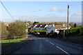
Autumn morning leaving Three Crosses
Image: © Ruth Sharville
Taken: 11 Nov 2008
0.07 miles
2
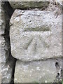
Ordnance Survey Cut Mark
This OS cut mark can be found on the barn conversion to the SE of the road. It marks a point 138.087m above mean sea level.
Image: © Adrian Dust
Taken: 1 Jun 2014
0.08 miles
3
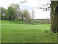
Gower Golf Club 16th green and 14th tee
At this point the course does consist of several parallel holes making their way up and down a gradient. The succession of par 4 holes are rendered more challenging by a deep ditch which bisects their fairways.
Image: © Stuart Logan
Taken: 22 Apr 2014
0.09 miles
4
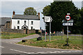
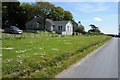
Three Crosses: farmhouse by road junction
Looking north east by the turning to the Gower Golf Club. This is one of the few older farmhouses surviving on Gower and it won a recent Gower Society Award for restoration
Image: © Martin Bodman
Taken: 10 Jun 2006
0.10 miles

7
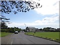
Open space in Three Crosses and Welsh Independent Chapel
The open space is designated as a play area. The chapel dates from 1878 Image
Image: © David Smith
Taken: 2 Jun 2018
0.20 miles
8
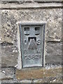
Ordnance Survey Flush Bracket (G3821)
This OS Flush Bracket can be found on the NW face of the school building. It marks a point 127.335m above mean sea level.
Image: © Adrian Dust
Taken: 1 Jun 2014
0.21 miles