IMAGES TAKEN NEAR TO
Llotrog, Penclawdd, SWANSEA, SA4 3JX
Introduction
This page details the photographs taken nearby to SA4 3JX by members of the Geograph project.
The Geograph project started in 2005 with the aim of publishing, organising and preserving representative images for every square kilometre of Great Britain, Ireland and the Isle of Man.

There are currently over 7.5m images from over14,400 individuals and you can help contribute to the project by visiting https://www.geograph.org.uk
Image Map (Loading...)


Getting Data...Please wait
Leaflet Map data © OpenStreetMap
Images are licensed for reuse under creativecommons.org/licenses/by-sa/2.0
Notes
- Clicking on the map will re-center to the selected point.
- The higher the marker number, the further away the image location is from the centre of the postcode.
Image Listing (1 Images Found)
Images are licensed for reuse under creativecommons.org/licenses/by-sa/2.0
Image
Details
Distance
1
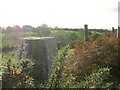
Trig pillar above Penclawdd
Obviously no longer in use, this trig pillar is now part of a hedgerow across the high point of the hill.
This is the view off towards the hills in the northwest of the Gower peninsula. I suspect the trig point was of more use surveying the Loughor estuary and Llanelli coast to the north. Due to the low level of land on the south side of the hedge I couldn't get that shot.
Image: © Nigel Davies
Taken: 10 Oct 2006
0.17 miles