IMAGES TAKEN NEAR TO
Misty Hills Close, SWANSEA, SA4 3JF
Introduction
This page details the photographs taken nearby to Misty Hills Close, SA4 3JF by members of the Geograph project.
The Geograph project started in 2005 with the aim of publishing, organising and preserving representative images for every square kilometre of Great Britain, Ireland and the Isle of Man.

There are currently over 7.5m images from over14,400 individuals and you can help contribute to the project by visiting https://www.geograph.org.uk
Image Map (Loading...)


Getting Data...Please wait
Leaflet Map data © OpenStreetMap
Images are licensed for reuse under creativecommons.org/licenses/by-sa/2.0
Notes
- Clicking on the map will re-center to the selected point.
- The higher the marker number, the further away the image location is from the centre of the postcode.
Image Listing (6 Images Found)
Images are licensed for reuse under creativecommons.org/licenses/by-sa/2.0
Image
Details
Distance
1
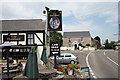
Three Crosses: The Poundffald
Inn by the turning to Pen-clawdd. Looking north-north-west
Image: © Martin Bodman
Taken: 10 Jun 2006
0.08 miles
2
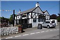
The Poundffald,Three Crosses
The Poundffald public house at Three Crosses.
Image: © Philip Halling
Taken: 17 May 2014
0.09 miles
3
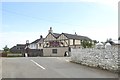
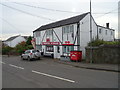
The Poundffald at Three Crosses
Since the picture was taken in 2014 Image this inn has been redecorated
Image: © David Smith
Taken: 2 Jun 2018
0.09 miles
4
Faded road markings at the edge of Three Crosses
The entrance to the village from the north passes a farm with a pull-off with bare earth on the left. Before the 20mph sign there are faded yellow marks on the road to indicate the approach to the village
Image: © David Smith
Taken: 2 Jun 2018
0.14 miles
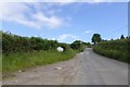
6
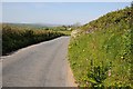
Road west of Three Crosses
Country road between Three Crosses and Pen-Clawdd.
Image: © Philip Halling
Taken: 17 May 2014
0.23 miles