IMAGES TAKEN NEAR TO
Clos Tregwyr, SWANSEA, SA4 3GU
Introduction
This page details the photographs taken nearby to Clos Tregwyr, SA4 3GU by members of the Geograph project.
The Geograph project started in 2005 with the aim of publishing, organising and preserving representative images for every square kilometre of Great Britain, Ireland and the Isle of Man.

There are currently over 7.5m images from over14,400 individuals and you can help contribute to the project by visiting https://www.geograph.org.uk
Image Map (Loading...)


Getting Data...Please wait
Leaflet Map data © OpenStreetMap
Images are licensed for reuse under creativecommons.org/licenses/by-sa/2.0
Notes
- Clicking on the map will re-center to the selected point.
- The higher the marker number, the further away the image location is from the centre of the postcode.
Image Listing (61 Images Found)
Images are licensed for reuse under creativecommons.org/licenses/by-sa/2.0
Image
Details
Distance
1
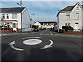
Heol y Gwartheg Gowerton
Looking towards houses in Heol y Gwartheg across a mini-roundabout in the B4295 Gorwydd Road.
Image: © Jaggery
Taken: 25 Sep 2013
0.02 miles
2
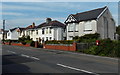
Postbox and houses in Gorwydd Road Gowerton
Viewed across the B4295 Gorwydd Road.
Image: © Jaggery
Taken: 25 Sep 2013
0.06 miles
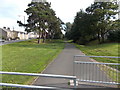
3
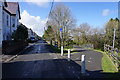
Woodlands, Gowerton
A path following a former railway has been lost in new housing development, but the path now follows this slightly older residential road.
Image: © Bill Boaden
Taken: 6 Apr 2016
0.08 miles
5
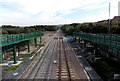
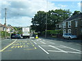
West Wales Line SE of Gowerton railway station
Viewed from the station footbridge looking in the direction of Swansea station, about 7km away.
Image: © Jaggery
Taken: 25 Sep 2013
0.11 miles
6
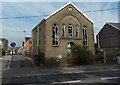
Fenced-off former Tabernacle Chapel in Gowerton
Viewed across Gorwydd Road. This late September 2013 view shows that a once proud chapel has become an eyesore. All the windows are broken. An uprooted estate agents' board lies forlornly against a wall.
Image: © Jaggery
Taken: 25 Sep 2013
0.12 miles
7
Tree-lined path between Gorwydd Road and Woodlands in Gowerton
Gorwydd Road is on the left. Houses in Woodlands (shown as Woodlands Terrace on one map) are out of shot on the right.
Image: © Jaggery
Taken: 25 Sep 2013
0.12 miles
8
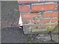
Ordnance Survey Cut Mark
This OS cut mark can be found on the wall post of No92 Gorwydd Road. It marks a point 23.339m above mean sea level.
Image: © Adrian Dust
Taken: 15 Feb 2023
0.12 miles
9
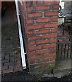
Ordnance Survey Cut Benchmark
Cut mark can be found on Left Hand Side pillar on 92 Gorwydd Road.
Image: © John Jenkins
Taken: 14 Feb 2023
0.12 miles
10
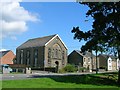
Tabernacle Welsh Independent chapel, Gorwydd Rd, Gowerton
Built in 1883, this picture was taken shortly after permission was granted for its demolition and replacement with new houses.
Image: © Simon Mortimer
Taken: 9 Aug 2012
0.12 miles