IMAGES TAKEN NEAR TO
Ffordd Beck, SWANSEA, SA4 3GE
Introduction
This page details the photographs taken nearby to Ffordd Beck, SA4 3GE by members of the Geograph project.
The Geograph project started in 2005 with the aim of publishing, organising and preserving representative images for every square kilometre of Great Britain, Ireland and the Isle of Man.

There are currently over 7.5m images from over14,400 individuals and you can help contribute to the project by visiting https://www.geograph.org.uk
Image Map (Loading...)


Getting Data...Please wait
Leaflet Map data © OpenStreetMap
Images are licensed for reuse under creativecommons.org/licenses/by-sa/2.0
Notes
- Clicking on the map will re-center to the selected point.
- The higher the marker number, the further away the image location is from the centre of the postcode.
Image Listing (23 Images Found)
Images are licensed for reuse under creativecommons.org/licenses/by-sa/2.0
Image
Details
Distance
1
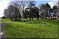
Park land by the B4295
A bit of green space created in new housing development in Gowerton.
Image: © Bill Boaden
Taken: 6 Apr 2016
0.10 miles
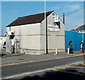
3
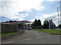
Esso filling station and Tesco Express store, Gowerton
Image: © David Smith
Taken: 2 Jun 2018
0.13 miles
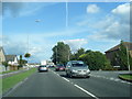
5
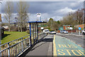
Bus stop on Victoria Road, Gowerton
The major road across the valley to Gorseinon.
Image: © Bill Boaden
Taken: 6 Apr 2016
0.20 miles
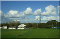
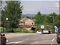
6
Entrance to Gowerton RFC
This is the entrance to Gowerton Rugby Football Club's ground, located between the West Wales Line railway and a river, the Afon Llan. Viewed across Victoria Road from the corner of Fairwood Terrace.
Image: © Jaggery
Taken: 29 Sep 2013
0.20 miles
7
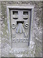
Ordnance Survey Flush Bracket (G3823)
This OS Flush Bracket can be found on the NW wall of the railway bridge. It marks a point 8.334m above mean sea level.
Image: © Adrian Dust
Taken: 1 Jun 2014
0.21 miles
8
Mill Street, Gowerton
Looking north from the junction with Gorwydd Road towards the railway bridge. The houses on the far side of the bridge are on Victoria Road.
Image: © Simon Mortimer
Taken: 9 Aug 2012
0.21 miles
9
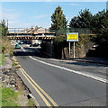
Low bridge and a lower tunnel, Victoria Road, Gowerton
The B4296 Victoria Road passes under the West Wales Line railway. Height shown on the bridge is 11' 0". Lights on the OVERHEIGHT VEHICLE TURN BACK sign illuminate when appropriate. I wonder how many vehicles collided with the bridge before the sign was installed, and how many collisions this sign has prevented. The tunnel for pedestrians on the right has a headroom of about 6 feet.
Image: © Jaggery
Taken: 29 Sep 2013
0.21 miles
10
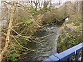
Afon Llan
Bridge over Afon Llan, Gowerton.
Image: © Alan Hughes
Taken: 20 Mar 2019
0.21 miles