IMAGES TAKEN NEAR TO
Banc Bach, SWANSEA, SA4 3FL
Introduction
This page details the photographs taken nearby to Banc Bach, SA4 3FL by members of the Geograph project.
The Geograph project started in 2005 with the aim of publishing, organising and preserving representative images for every square kilometre of Great Britain, Ireland and the Isle of Man.

There are currently over 7.5m images from over14,400 individuals and you can help contribute to the project by visiting https://www.geograph.org.uk
Image Map
Images are licensed for reuse under creativecommons.org/licenses/by-sa/2.0
Notes
- Clicking on the map will re-center to the selected point.
- The higher the marker number, the further away the image location is from the centre of the postcode.
Image Listing (31 Images Found)
Images are licensed for reuse under creativecommons.org/licenses/by-sa/2.0
Image
Details
Distance
5
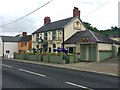
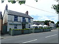
The Royal Oak
The Royal Oak, Penclawdd.
Image: © Alan Hughes
Taken: 23 Jul 2018
0.09 miles
6
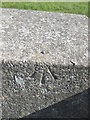
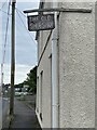
Ordnance Survey Rivet
This OS rivet can be found on the sea wall, Beach Road. It marks a point 7.669m above mean sea level.
Image: © Adrian Dust
Taken: 4 Jun 2015
0.10 miles
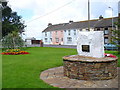
7
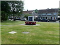
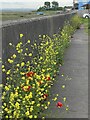
Penclawdd War Memorial
At the junction of Beach Road and Cae Folland
Image: © Eirian Evans
Taken: 21 May 2022
0.11 miles
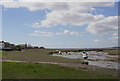
10
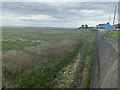
Pen-clawdd War Memorial
The village war memorial also commemorates local workers. Behind the row of terraced cottages is the tidal estuary of the Loughor.
Image: © Colin Smith
Taken: 24 Jul 2009
0.13 miles