IMAGES TAKEN NEAR TO
Hill Street, SWANSEA, SA4 3BT
Introduction
This page details the photographs taken nearby to Hill Street, SA4 3BT by members of the Geograph project.
The Geograph project started in 2005 with the aim of publishing, organising and preserving representative images for every square kilometre of Great Britain, Ireland and the Isle of Man.

There are currently over 7.5m images from over14,400 individuals and you can help contribute to the project by visiting https://www.geograph.org.uk
Image Map
Images are licensed for reuse under creativecommons.org/licenses/by-sa/2.0
Notes
- Clicking on the map will re-center to the selected point.
- The higher the marker number, the further away the image location is from the centre of the postcode.
Image Listing (56 Images Found)
Images are licensed for reuse under creativecommons.org/licenses/by-sa/2.0
Image
Details
Distance
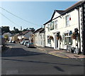
1

Gowerton Library
Located in Mansel Street, part of the City and County of Swansea library service.
Image: © Jaggery
Taken: 29 Sep 2013
0.06 miles
2

Capel Bethel Chapel, Tregwyr / Gowerton
Adfail trist Capel y Trefnyddion Bethel, Tregwyr. Cyn codi'r capel addolai'r aelodau mewn ysgubor yn Waunarlwydd. Codwyd yr addoldy presennol yn 1873. Un person adnabyddus a addolai yma oedd William (Mabon) Abraham (1842-1922), llywydd cyntaf Undeb Glowyr De Cymru. Yn anffodus caewyd y capel yn 2000 oherwydd cyflwr yr adeilad.
The sad ruin of Bethel Welsh Methodist Chapel in Gowerton. The early worshippers met in a barn in Waunarlwydd and the present chapel was built in 1873. One notable member who worshipped at Bethel was William (Mabon) Abraham (1842-1922), the first president of the South Wales Coal Miners. Sadly, due to the state of the building the chapel finally closed its doors in July 2000.
Image: © Alan Richards
Taken: 31 Aug 2012
0.07 miles
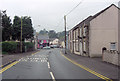
3
Mount Street Gowerton
A one-way traffic flow (away from the camera) and a 20mph speed limit are in force
along this part of Mount Street. The Gower pub http://www.geograph.org.uk/photo/3679012 is on the right.
Image: © Jaggery
Taken: 29 Sep 2013
0.07 miles
4

Derelict former Bethel chapel viewed from the west, Gowerton
The former Calvinistic Methodist chapel in Sterry Road was built in 1873.
The chapel closed down in July 2000 because of the poor state of the building.
Image: © Jaggery
Taken: 29 Sep 2013
0.07 miles
5

Derelict former Bethel chapel viewed from the east, Gowerton
The former Calvinistic Methodist chapel in Sterry Road was built in 1873.
The chapel closed down in July 2000 because of the poor state of the building.
Image: © Jaggery
Taken: 29 Sep 2013
0.07 miles
6
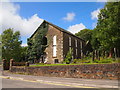
Bethel Chapel, Gowerton
Disused since 2000.
Image: © Chris Andrews
Taken: 26 Jul 2017
0.07 miles
7

Western end of Mansel Street, Gowerton
Looking west towards Mount Street.
Image: © Jaggery
Taken: 29 Sep 2013
0.07 miles
9
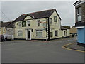
Welcome to Gower PH
The pub appears to have been closed for some time.
Image: © John M
Taken: 31 Oct 2017
0.08 miles
10

Mansel Workmen's Club, Gowerton
Viewed across Cecil Road.
Image: © Jaggery
Taken: 29 Sep 2013
0.08 miles