IMAGES TAKEN NEAR TO
Gowerton, SWANSEA, SA4 3BP
Introduction
This page details the photographs taken nearby to SA4 3BP by members of the Geograph project.
The Geograph project started in 2005 with the aim of publishing, organising and preserving representative images for every square kilometre of Great Britain, Ireland and the Isle of Man.

There are currently over 7.5m images from over14,400 individuals and you can help contribute to the project by visiting https://www.geograph.org.uk
Image Map (Loading...)


Getting Data...Please wait
Leaflet Map data © OpenStreetMap
Images are licensed for reuse under creativecommons.org/licenses/by-sa/2.0
Notes
- Clicking on the map will re-center to the selected point.
- The higher the marker number, the further away the image location is from the centre of the postcode.
Image Listing (101 Images Found)
Images are licensed for reuse under creativecommons.org/licenses/by-sa/2.0
Image
Details
Distance
1
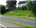
Parking area for authorised vehicles only in Gowerton
The blue Authorised vehicles only sign is on the west side of the B4295 Gorwydd Road.
Image: © Jaggery
Taken: 15 Aug 2015
0.02 miles
2
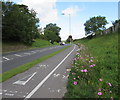
Colourful bank edge in Gowerton
Flowers line the bottom of a bank alongside the B4295 Gorwydd Road in mid August 2015.
Image: © Jaggery
Taken: 15 Aug 2015
0.03 miles
3
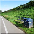
Gorwydd Road litter bin and bench, Gowerton
Alongside the B4295 Gorwydd Road at the bottom of a bank below Elba Street.
Image: © Jaggery
Taken: 15 Aug 2015
0.03 miles
4
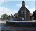
St John's Church, Gowerton
The Church in Wales church is set back from a bend in Church Street. The church hall is on the left.
Image: © Jaggery
Taken: 29 Sep 2013
0.05 miles
5
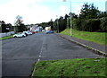
Free car park in Gowerton
Located on the north side of the B4295 Gorwydd Road,
the rectangular car park is about 80 metres long and 15 metres wide.
Image: © Jaggery
Taken: 15 Aug 2015
0.06 miles
6
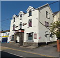
The London & North Western (LNW) pub, Gowerton
Viewed across Sterry Road. Although deep within the area of the former Great Western Railway (GWR), Gowerton also had a London & North Western (LNW) presence for many years. Gowerton North (now Gowerton) station was on the GWR line between Swansea and Llanelli. Gowerton South (closed in 1964) was part of the LNW route from Pontarddulais to Swansea Victoria.
Image: © Jaggery
Taken: 29 Sep 2013
0.06 miles
7
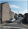
Western end of Church Street Gowerton
Viewed from Mill Street.
Image: © Jaggery
Taken: 29 Sep 2013
0.06 miles
8
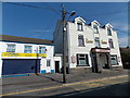
The Contented Sole, Gowerton
Traditional fish and chips shop in Sterry Road. The LNW http://www.geograph.org.uk/photo/3678076 is next door.
Image: © Jaggery
Taken: 29 Sep 2013
0.06 miles
9
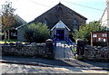
Rechabite Community Hall, Gowerton
Located in Church Street opposite St John's Church. http://www.geograph.org.uk/photo/3678270 The small extension on the left, here mostly hidden by vegetation, is used as a police office. The nearest police station is in Gorseinon.
Image: © Jaggery
Taken: 29 Sep 2013
0.06 miles
10
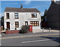
Former Gowerton post office
The large George V postbox in the wall is the only reminder that the house on the right was until recently Gowerton's post office, which is now (2013) located inside the nearby Nisa Local shop. http://www.geograph.org.uk/photo/3677783
Image: © Jaggery
Taken: 29 Sep 2013
0.07 miles