IMAGES TAKEN NEAR TO
Cedar Close, SWANSEA, SA4 3AR
Introduction
This page details the photographs taken nearby to Cedar Close, SA4 3AR by members of the Geograph project.
The Geograph project started in 2005 with the aim of publishing, organising and preserving representative images for every square kilometre of Great Britain, Ireland and the Isle of Man.

There are currently over 7.5m images from over14,400 individuals and you can help contribute to the project by visiting https://www.geograph.org.uk
Image Map (Loading...)


Getting Data...Please wait
Leaflet Map data © OpenStreetMap
Images are licensed for reuse under creativecommons.org/licenses/by-sa/2.0
Notes
- Clicking on the map will re-center to the selected point.
- The higher the marker number, the further away the image location is from the centre of the postcode.
Image Listing (18 Images Found)
Images are licensed for reuse under creativecommons.org/licenses/by-sa/2.0
Image
Details
Distance
1
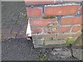
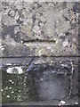
Ordnance Survey Cut Mark
This OS cut mark can be found on the wall post of No92 Gorwydd Road. It marks a point 23.339m above mean sea level.
Image: © Adrian Dust
Taken: 15 Feb 2023
0.07 miles
2
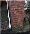
Ordnance Survey Cut Benchmark
Cut mark can be found on Left Hand Side pillar on 92 Gorwydd Road.
Image: © John Jenkins
Taken: 14 Feb 2023
0.07 miles
3
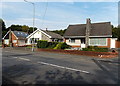
Gorwydd Road bungalows in Gowerton
Viewed across the B4295 Gorwydd Road.
Image: © Jaggery
Taken: 25 Sep 2013
0.07 miles
4
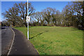
Green space by Oakwood Drive
In the middle of new housing development in Gowerton, some green space has deliberately been retained.
Image: © Bill Boaden
Taken: 6 Apr 2016
0.08 miles
5
Ordnance Survey Cut Mark
This OS cut mark can be found on the school wall. It marks a point 35.375m above mean sea level.
Image: © Adrian Dust
Taken: 13 Dec 2015
0.10 miles
6

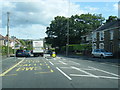
Oakwood Drive, Gowerton
Looking north from the junction with Gower Rise. The road forms part of Route 4 of the National Cycle Network.
Image: © Simon Mortimer
Taken: 9 Aug 2012
0.11 miles
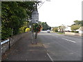
8
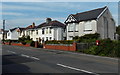
Postbox and houses in Gorwydd Road Gowerton
Viewed across the B4295 Gorwydd Road.
Image: © Jaggery
Taken: 25 Sep 2013
0.14 miles
10
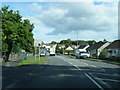
SE boundary of Gowerton
On reaching Gowerton from Waunarlwydd, the B4295 Swansea Road is renamed the B4295 Gorwydd Road.
Image: © Jaggery
Taken: 25 Sep 2013
0.15 miles