IMAGES TAKEN NEAR TO
Glanrhyd, CARDIGAN, SA43 3NX
Introduction
This page details the photographs taken nearby to SA43 3NX by members of the Geograph project.
The Geograph project started in 2005 with the aim of publishing, organising and preserving representative images for every square kilometre of Great Britain, Ireland and the Isle of Man.

There are currently over 7.5m images from over14,400 individuals and you can help contribute to the project by visiting https://www.geograph.org.uk
Image Map (Loading...)


Getting Data...Please wait
Leaflet Map data © OpenStreetMap
Images are licensed for reuse under creativecommons.org/licenses/by-sa/2.0
Notes
- Clicking on the map will re-center to the selected point.
- The higher the marker number, the further away the image location is from the centre of the postcode.
Image Listing (2 Images Found)
Images are licensed for reuse under creativecommons.org/licenses/by-sa/2.0
Image
Details
Distance
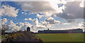
1

Rain over the Preselis
The clouds are thickening and precipitation seems already to have started in this view southwest towards the mountains; Trefigin Farm silhouetted to the right.
Image: © Natasha Ceridwen de Chroustchoff
Taken: 5 Jan 2008
0.09 miles
2
CCF Feed Blending Plant: Llantood
Clynderwen and Cardiganshire Farmers is a farmers' co-operative founded in 1904. The initial branches were at rail links in Pembrokeshire, but in the 1950s it spread into Cardiganshire, and in the 1990s extended its operations all over rural Wales.
Image: © Dylan Moore
Taken: 31 Mar 2016
0.14 miles