IMAGES TAKEN NEAR TO
CARDIGAN, SA43 3NS
Introduction
This page details the photographs taken nearby to SA43 3NS by members of the Geograph project.
The Geograph project started in 2005 with the aim of publishing, organising and preserving representative images for every square kilometre of Great Britain, Ireland and the Isle of Man.

There are currently over 7.5m images from over14,400 individuals and you can help contribute to the project by visiting https://www.geograph.org.uk
Image Map (Loading...)


Getting Data...Please wait
Leaflet Map data © OpenStreetMap
Images are licensed for reuse under creativecommons.org/licenses/by-sa/2.0
Notes
- Clicking on the map will re-center to the selected point.
- The higher the marker number, the further away the image location is from the centre of the postcode.
Image Listing (4 Images Found)
Images are licensed for reuse under creativecommons.org/licenses/by-sa/2.0
Image
Details
Distance
1
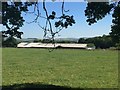
Trefigin Farm
Trefigin Farm, nestling below the hillside.
Image: © Alan Hughes
Taken: 27 Jun 2018
0.03 miles
2
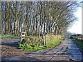
Lane to Trefigin
The chicken farm is just behind the copse: the main farm is down the lane.
Image: © Dylan Moore
Taken: 3 Jan 2008
0.04 miles
3
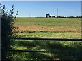
Field at Croes y Fran
Entrance to field at Croes y Fran.
Image: © Alan Hughes
Taken: 27 Jun 2018
0.16 miles
4
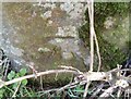
Ordnance Survey Cut Mark
This OS cut mark can be found on the gatepost north side of the road. It marks a point 170.968m above mean sea level.
Image: © Adrian Dust
Taken: 17 Feb 2020
0.19 miles