IMAGES TAKEN NEAR TO
CARDIGAN, SA43 3NR
Introduction
This page details the photographs taken nearby to SA43 3NR by members of the Geograph project.
The Geograph project started in 2005 with the aim of publishing, organising and preserving representative images for every square kilometre of Great Britain, Ireland and the Isle of Man.

There are currently over 7.5m images from over14,400 individuals and you can help contribute to the project by visiting https://www.geograph.org.uk
Image Map
Images are licensed for reuse under creativecommons.org/licenses/by-sa/2.0
Notes
- Clicking on the map will re-center to the selected point.
- The higher the marker number, the further away the image location is from the centre of the postcode.
Image Listing (6 Images Found)
Images are licensed for reuse under creativecommons.org/licenses/by-sa/2.0
Image
Details
Distance
1
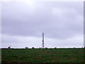
Mast with sheep
Several telecommunications masts are sited on the high ground southwest of Llandudoch/St Dogmaels.
Image: © Natasha Ceridwen de Chroustchoff
Taken: 29 Dec 2007
0.11 miles
2
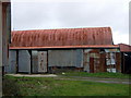
Patchwork barn
Corrugated metal outbuildings at Penwaun farm.
Image: © Natasha Ceridwen de Chroustchoff
Taken: 29 Dec 2007
0.13 miles
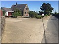
3
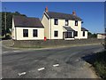
Croes y Fran
House at the crossroads at Croes y Fran.
Image: © Alan Hughes
Taken: 27 Jun 2018
0.14 miles
4
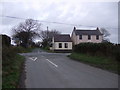
Croes-y-fran
The name means 'Crow's cross'.
Image: © Natasha Ceridwen de Chroustchoff
Taken: 29 Dec 2007
0.15 miles
5
Property for sale
House for sale at Croes y Fran.
Image: © Alan Hughes
Taken: 27 Jun 2018
0.18 miles
6
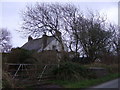
Waunsegur Uchaf
'Higher Idle Meadow' is the unusual name of this place.
2022 Sadly, the name appears to have been changed to Meadow Cottage (judging from the sign outside). The trend for substituting English for Welsh names has been gaining ground for a while and has angered many in Wales who feel it represents a loss of heritage.
Image: © Natasha Ceridwen de Chroustchoff
Taken: 29 Dec 2007
0.21 miles