IMAGES TAKEN NEAR TO
Poppit, CARDIGAN, SA43 3LP
Introduction
This page details the photographs taken nearby to SA43 3LP by members of the Geograph project.
The Geograph project started in 2005 with the aim of publishing, organising and preserving representative images for every square kilometre of Great Britain, Ireland and the Isle of Man.

There are currently over 7.5m images from over14,400 individuals and you can help contribute to the project by visiting https://www.geograph.org.uk
Image Map (Loading...)


Getting Data...Please wait
Leaflet Map data © OpenStreetMap
Images are licensed for reuse under creativecommons.org/licenses/by-sa/2.0
Notes
- Clicking on the map will re-center to the selected point.
- The higher the marker number, the further away the image location is from the centre of the postcode.
Image Listing (30 Images Found)
Images are licensed for reuse under creativecommons.org/licenses/by-sa/2.0
Image
Details
Distance
1

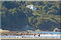
Pembrokeshire coast near Poppit Sands
Cardigan Island and the Ceredigion coastline across the other side of the bay.
Image: © Mat Fascione
Taken: 3 Jun 2019
0.01 miles
3
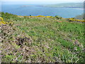
Hillside beside the Pembrokeshire Coast Path
This section of the footpath passes hillside where gorse and bracken have taken over. The view is over part of Cardigan Bay towards Cardigan Island.
Image: © Jeremy Bolwell
Taken: 30 Apr 2011
0.08 miles
4

Sheep overlooking Poppit Sands and the Teifi estuary
Image: © Mat Fascione
Taken: 3 Jun 2019
0.10 miles
5
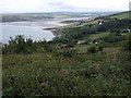
Penrhyn and the Teifi estuary
Looking down from Brynawelon cottage towards Penrhyn where the first coastguard station was established. Beyond is the Teifi estuary and Poppit Sands with Cardigan Bar visible across the mouth of the estuary.
There is a footpath marked on the map as running past here to the coast, but it is not discernible on the ground.
Penrhyn Castle is on the left of the picture but obscured.
Image: © Natasha Ceridwen de Chroustchoff
Taken: 18 Jul 2008
0.12 miles
6
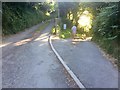
Track junction
Track leading to Penrhyn Mawr.
Image: © Alan Hughes
Taken: 27 Jun 2018
0.12 miles


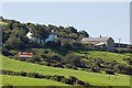
9

Penrhyn
Hillside above Penrhyn Castle with Teifi estuary and Gwbert beyond.
Image: © Alan Hughes
Taken: 27 Jun 2018
0.14 miles